


15
••••••••••••••••••••••••••••••••••••
NAVIONICS Electronic Charts
NAVIONICS ELECTRONIC CHARTS
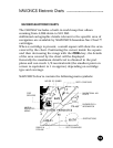
The GEONAV includes a built-in world map that allows
zooming from 4,096 down to 512 NM.
Additional cartographic details relevant to the specific area of
navigation are available by NAVIONICS Seamless Nav-Chart™
cartridges.
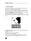
When a cartridge is present, a small square will show the area
covered by the chart. Positioning the cursor inside the square
and then decreasing the range with the ZOOM+ key, the details
of the area covered by the chart will be displayed.
Generally the maximum detail level is obtained in the port
plans and can reach 1/8 nautical mile (the smallest point on
screen is equivalent to 1 m approx.) depending on cartridge
type and coverage.
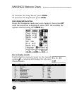
NAVIONICS charts contain the following main symbols:
•
•
•
•
•
•
•
•
•
•
•
•
•
•
•
•
•
•
•
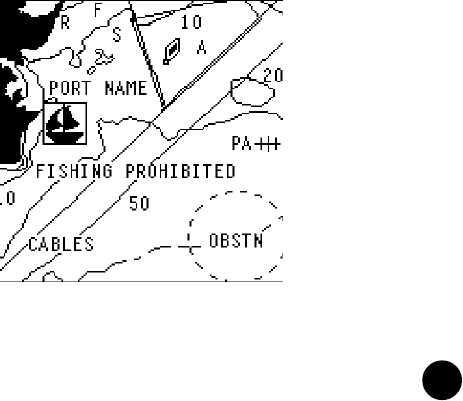
NATURE OF SEABED
•
•
•
• • • • • • • • • • •
DEPTH CONTOURS
• • • • • • • • • • • • • • • • • • • • • • •
•
•
•
•
•
•
• • • • • • • • • • • • • •
NAVIGATIONAL AID:
LIGHTS
• • • • • •
SHIPWRECKS &
INFORMATION
• • • • • • • •
OBSTRUCTIONS
•
•
•
•
•
•
•
•
•
•
•
•
•
•
•
•
• • • • • • • •
SPOT SOUNDINGS
•
•
•
•
•
•
•
•
•
•
• • • • •
CABLES &
PIPELINE
• • • • • • • • • • • •
LIMITS &
RESTRICTED
AREAS
•
•
•
•
•
•
• • • • • • • • • • • • • • • • • •
PORT
SERVICES