


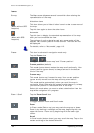


User's manual MobileNavigator | 5
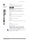
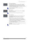
- 90 - Representation of the map in navigation mode
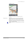
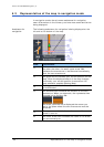
6.3 Representation of the map in navigation mode
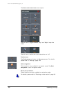
In navigation mode, there is some assistance for navigation,
some information on the itinerary and one more command button
being displayed:
Assistance for
navigation
The following assistance for navigation is being displayed at the
left and at the bottom of the map:
Field Information
c
If there are two manoeuvres to be executed quickly
one after the other, the small upper arrow field
indicates the manoeuvre to be executed immediately
after the next manoeuvre.
d
The green arrow indicates your current position on the
map. Since the displayed sector of the map changes
continually your current position is centred on the
map whenever possible (Moving Map).
e
The bigger arrow field indicates the next manoeuvre
to be executed.
f
The distance field indicates the distance to the next
manoeuvre. When you approach, the representations
changes into a distance bar:
The more yellow bars are displayed the nearer you
are to the place where the next manoeuvre must be
executed.
g
The upper street field indicates the name of the next
street to turn on.
h
The lower street field indicates the name of the street
you are currently on.