


User's manual MobileNavigator | 5
User's manual Table of contents 15
2.3 The basic principle of navigation
MobileNavigator The time of complicated and frustrating inquiries on the right way
in folded maps is over. From now on MobileNavigator, your
navigation system, will guide you, based on satellite information,
quickly and safely to your destination.
GPS-based
navigation
The Global Positioning System (GPS) has originally been
developed in the 70ies, as a weapon guidance system for the
American forces.
The GPS is based on 24 satellites, which are in orbit round the
earth and which are permanently emitting signals. The GPS
receiver receives these signals and calculates, based on the
runtime of the signals, his distance from the respective satellites.
This information serves for calculation your current geographic
position.
The signals of at least three satellites are needed to determine
the longitude and the latitude. With the signals of at least four
satellites the elevation may be calculated, too. The determination
has an accuracy of about 3 yards.
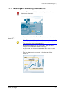
Navigation with GPS The delivered maps contain the geographic coordinates of the
points of interest, streets and towns they represent. Thus the
navigation system can calculate a route from a given start point
to a given destination point.
In case your navigation system receives the signals of at least
three satellites it may determine your current position and
represent it on the map. This position may then serve as start
point for navigation purposes.
As the determination and representation of your position is
carried out once a second, you may watch your movements on
the map.
Traffic information
with TMC)
The Traffic Message Channel (TMC) provides the navigation
system with the latest traffic information. A TMC module, which is
available as accessory receives these signals broadcasted by
radio stations.
TMC Operating mode The Traffic Message Channel (TMC) is based on a news
system. Traffic information is recorded continually this is done
automatically by sensors on the motorways and by the police.
This information is then forwarded to the radio stations without
delay. It is digitally coded, differentiated according to routes and
driving directions and transmitted inaudibly.
The TMC-receiver extracts the TMC data from the RDS signal and
provides the navigation software with them. Current traffic
obstructions may then be displayed.
The reported obstructions may be considered for route
calculation. In case of obstructions on the computed itinerary,
they may be used for computing an alternative route, which
evades the obstruction.
MobileNavigator features dynamic navigation, which is well
adapted to the current traffic situation.