


30
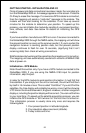
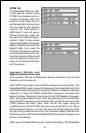
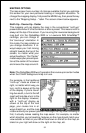
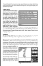
pear. Press the MAP key again
to view a “split-screen” map
and sonar display as shown
below. Pressing the MAP key
again returns the unit to the
original mapping display.
Boxes on the right side of the
screen shown at the bottom of
this page show your course over
ground (COG), or direction
you’re heading, boat speed
(SOG), present time (TOD or
Time Of Day), and navigation
information if you recall a way-
point. (The screen at right shows
navigation data to a recalled
waypoint.) All of the boxes on
the right side of the screen can
be replaced with others. In this
manner you can customize the
screen to your needs. See the
Customization section for a de-
tailed description of the boxes
not shown on this screen.
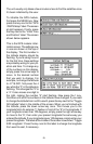
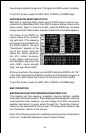
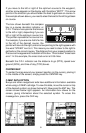
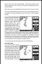
The box in the upper right corner of the screen is a combination navigation
display. A compass shows your current
course over ground at the top of the box.
This is the direction you’re travelling.
Your course over ground (COG) is also
shown in digital numbers in the bottom
left corner of this box. The course over
ground in this example is 210 degrees.
When a waypoint is recalled (see the waypoint navigation section), the
direction to the waypoint, or bearing, is shown in the bottom right corner of
this box (BRG).
The arrow that points up always shows in the middle of this box. This arrow
points to the bearing of the recalled waypoint on the compass. In this
example, the bearing is 197 degrees. If you steer the boat so that the arrow
that points up is always in line with your course over ground, then you’ll
always steer the shortest, most direct route to the waypoint.