


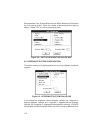

8-3
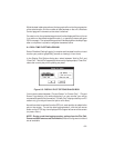
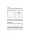
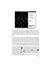
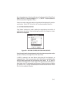
Figure 8-4: SATELLITE VISIBILITY SKY VIEW
The “North Up” format locates your selected position at the center of nine
concentric rings. The outermost ring represents the horizon at this location;
the next smaller ring represents 10° elevation above the horizon. Each
successive ring depicts another 10° above the horizon, with the center of the
sky chart (cross hair) representing the sky directly above the selected
location.
All satellites which are visible at the selected location and at the indicated
time (and are at an elevation at, or above, the entered mask angle) are plotted
on the sky chart at their appropriate elevations and azimuths. Knowing the
azimuth and elevation of each visible satellite is useful in determining
whether its signal will be blocked by buildings, mountains or other obstructions.
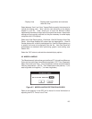
Horizontal Dilution of Precision (HDOP) and Position Dilution of Precision
(PDOP) are displayed if the designated fix type (3D or 2D) can be achieved
(if not, they appear dashed). (See Appendix A for a definition of these terms.)
When the satellites appear they will be stationary. To activate the satellites
orbital motion, select "Go"( ). As the time changes (by five minute intervals),
each satellite moves across the graphic sky chart in its individual orbit. To
adjust the speed of the satellites, select the “Slower” ( ) or “Faster” (
) buttons. Select the “Pause” ( ) button to temporarily stop the satellite
movement; select “Go” ( ) to resume satellite motion. The bar graph below
the speed buttons indicates the speed at which the time will change. Select
“OK” to return to the Main Menu.
Computer systems without a mouse can use the arrow keys to control update