


6-10
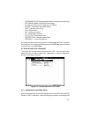
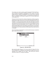
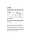
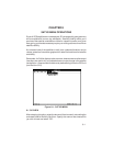
Figure 6-6: REAL TIME PLOT EXAMPLE
If “File and Screen” is selected, the “.TRK” file created will follow the format
discussed in Section 6.1, and may be used as an input file for many popular
spreadsheet software programs. Each row contains a position fix. Any non-
trailing empty data fields in the file will contain spaces in order to maintain
column integrity.
First to appear in the file will be a header (H record) followed by one software
identification record (I record), specifying the name and version number of
the software producing the file. Next will appear another H record followed
by one coordinate system record (U record) naming the coordinate system
in which the file is formatted. A third H record follows with one map datum
record (M record) containing the following information: M (the record type);
R (the altitude reference used, E=ellipsoid); DATUM NAME (the map datum
used); IDX (the index number of the map datum); DA (delta earth radius); DF
(delta flattening factor); and DX, DY and DZ (delta earth center parameters).
Only one U record and one M record (and their associated headers) appear
in the file unless data in one of these fields changes during a logging session.
Occurring next will be another header (providing column titles) followed by
multiple real time logging data records (N records). An N record will always
include the following data: N (record type), latitude and longitude (or easting
and northing for grid coordinates), date (DD-MMM-YY) and time (UTC in
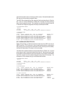
form of HH:MM:SS). The following is an example of a real time logging file: