


6-5
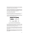
required information (drive, directory and file name). Indicate the destination
file name for the proximity waypoint data.
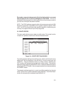
The ASCII file created follows the waypoint file format described in Section
6.2.1 (one “H” record followed by multiple “W” records), but with proximity
data in each waypoint record. An example of a proximity waypoint data file
in latitude and longitude (degrees/minutes) coordinates follows:
6.2.3 DOWNLOAD ROUTE DATA
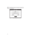
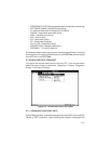
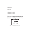
Select “Route Data” to download stored routes from the GPS unit into an
ASCII file with a “.RTE” extension. Upon choosing this selection, a dialog box
will prompt you for the required information (drive, directory and file name).
Indicate the destination file name for the route data.
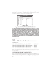
The ASCII file created follows the format described in Section 6.1 and will
show data for each route downloaded from the unit. Each grouping of data
for a specific route consists of one route identifier line (R record), one header
record (H record) and the related waypoint data lines (W records). An
example of a file created during a route download follows:
H SOFTWARE NAME & VERSION
I PCX5 2.00
H R DATUM IDX DA DF DX DY DZ
M E WGS 84 100 +0.000000e+00 +0.000000e+00 +0.000000e+00 +0.000000e+00 +0.000000e+00
H COORDINATE SYSTEM
U LAT LON DM
H IDNT LATITUDE LONGITUDE DATE TIME ALT DESCRIPTION PROXIMITY ;waypts
W HOME N3519.3776 W08540.4503 07-JUN-93 14:26:47-9999 MY HOUSE 1.00000e+03
W MARINA N3510.6819 W08536.0333 07-JUN-93 14:29:17-9999 GOOD FOOD HERE 2.00000e+02
W BRIDGE N3522.8349 W08551.1903 07-JUN-93 14:30:16-9999 COUNTY ROAD BRIDGE 1.25000e+03
W FCOVE N3459.3816 W08527.8865 07-JUN-93 14:31:15-9999 FISHING COVE 2.50000e+03
W WRECK N3502.5195 W08602.9741 07-JUN-93 14:32:44-9999 NAVIGATION HAZARD 1.60934e+03
W FRED N3517.7816 W08605.0523 07-JUN-93 14:53:40-9999 FREDS HOUSE 1.00000e+04
H SOFTWARE NAME & VERSION
I PCX5 2.00
H R DATUM IDX DA DF DX DY DZ
M E WGS 84 100 +0.000000e+00 +0.000000e+00 +0.000000e+00 +0.000000e+00 +0.000000e+00
H COORDINATE SYSTEM
U LAT LON DM
R 00 LETS GO FISHING
H IDNT LATITUDE LONGITUDE DATE TIME ALT DESCRIPTION PROXIMITY ;waypts
W HOME N3519.3776 W08540.4503 07-JUN-93 14:26:47-9999 MY HOUSE 1.00000e+03
W FRED N3517.7816 W08605.0523 07-JUN-93 14:53:40-9999 FREDS HOUSE 1.00000e+04
W MARINA N3510.6819 W08536.0333 07-JUN-93 14:29:17-9999 GOOD FOOD HERE 2.00000e+02
W FCOVE N3459.3816 W08527.8865 07-JUN-93 14:31:15-9999 FISHING COVE 2.50000e+03
R 01 BACK TO THE HOUSE
H IDNT LATITUDE LONGITUDE DATE TIME ALT DESCRIPTION PROXIMITY ;waypts
W FCOVE N3459.3816 W08527.8865 07-JUN-93 14:31:15-9999 FISHING COVE 2.50000e+03
W MARINA N3510.6819 W08536.0333 07-JUN-93 14:29:17-9999 GOOD FOOD HERE 2.00000e+02
W FRED N3517.7816 W08605.0523 07-JUN-93 14:53:40-9999 FREDS HOUSE 1.00000e+04
W HOME N3519.3776 W08540.4503 07-JUN-93 14:26:47-9999 MY HOUSE 1.00000e+03