


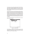
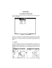
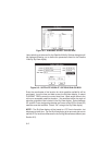
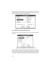

Figure 8-2: ALMANAC SELECT DIALOG BOX
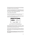
Upon selecting an almanac file, the Satellite Visibility Options dialog box will
be displayed allowing you to define the parameters used for the Satellite
Visibility SkyView display.
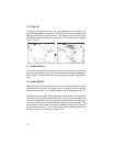
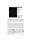
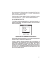
Figure 8-3: SATELLITE VISIBILITY OPTIONS DIALOG BOX
Enter the coordinates of the location for which satellite availability will be
previewed. Input the time and date to start the SkyView display, or select
CURRENT TIME to enter the current local time. Mask angle refers to the
minimum acceptable satellite elevation. No satellites below the angle of
elevation entered will be included in the SkyView display. Select between
3D- and 2D-Fixes, designating whether a minimum of four (3D) or three (2D)
satellites must be available. Select “OK” to begin the SkyView display.
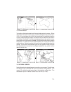
NOTE: The SkyView display will be based on UTC time information, but
displayed as local time. For the SkyView display to be accurate, be sure to
set the UTC to local time difference on the Config | Miscellaneous Menu (see
Section 9.5).
8-2