


24 GPSMAP 496 Owner’s Manual
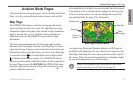
Aviation
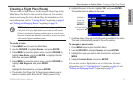
Basic Operation in Aviation Mode > Selecting an Approach
Understanding Vectors
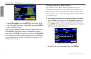
The Vectors? option, which appears after you select an approach,
determines how you navigate to the nal approach waypoint.
If you select Yes, the GPSMAP 496 creates an extension of the nal
course, beyond the nal approach waypoint in the database (nal
approach x [FAF]). On the Active Route Page, a Vector to Final
symbol appears beside the rst approach waypoint.
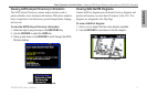
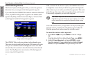
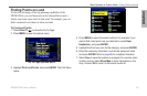
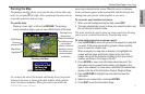
Active Approach Page
Using vectors in the approach
The GPSMAP 496 provides no guidance to the inbound course.
The course deviation needle on the graphic HSI remains off-center
until you are established on this nal approach course. The HSI
automatically slews (rotates to show the direction) to the inbound
course. The Map Page shows an extension of the nal approach
course using a bold magenta line.
If No is selected for the Vectors? option, the GPSMAP 496 creates
a straight-line course directly to the rst waypoint in the approach
(from wherever you are when you initiate the approach). This works
much like any other route with course guidance from point to point.
A turn usually required as you cross each waypoint.
CAUTION: Steep Turns are not allowed on an IFR (Instrument
Flight Rules) approach. Follow the approach plate or air trafc
control instructions to complete the approach without a steep
turn.
If air trafc control clears your approach to an airport, loading the
approach cancels your Direct To and initiates a route to the FAF.
Load the approach only when cleared by air trafc control.
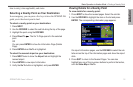
To cancel the vectors and/or approach:
1. Press Direct To , and press MENU on the Go To Page.
OR
From the Active Go To (or Active Route) Page, press MENU.
2. Highlight Cancel Approach, and press ENTER to cancel
the entire approach. If you enabled Vectors, highlight Cancel
Vectors, and press ENTER to navigate directly to the FAF.