


150 GPSMAP 496 Owner’s Manual
TIS > TIS Symbology
The GPSMAP 496 supports TIS input from a Garmin Mode S
transponder, such as the GTX 330.
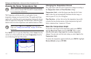
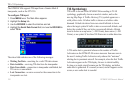
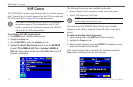
To congure TIS input:
1. Press MENU twice. The Main Menu appears.
2. Highlight the Setup tab.
3. Use the ROCKER to select the Interface sub tab.
4. Highlight the Serial Data Format eld, and use the ROCKER to
select TIS In.
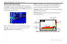
The status eld indicates one of the following messages:
Waiting For Data—searching for a valid TIS data stream.
Data Available
—receiving TIS data from the transponder.
Data Unavailable—connection to transponder established, but
TIS service is unavailable.
Lost Connection—an error occurred or the connection to the
transponder was lost.
•
•
•
•
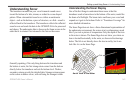
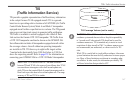
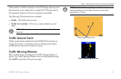
TIS Symbology
TIS trafc is shown on the GPSMAP 496 according to TCAS
symbology, graphically shown on an alert window, and on the
moving Map Page. A Trafc Advisory (TA) symbol appears as a
solid yellow circle. All other trafc is shown as a hollow white
diamond. Altitude deviation from own aircraft altitude is shown
above the target symbol if trafc is above own aircraft altitude, and
below the symbol if they are below own aircraft altitude. Altitude
trend is shown as an up arrow (>+500 ft/min), down arrow (<-500
ft/min), or no symbol if less than 500 ft/min rate in either direction.
A TIS audio alert is generated whenever the number of Trafc
Advisories on the GPSMAP 496 screen increases from one scan to
the next. Limiting Trafc Advisories only reduces the “nuisance”
alerting due to proximate aircraft. For example, when the rst Trafc
Advisories appear on the TIS display, the user is alerted audibly.
So long as a single aircraft remains on the TIS display, no further
audio alert is generated. If a second (or more) aircraft appears on the
screen, a new audio alert is sounded.