


37
GPS Information Page
Reference
GPS Information Page
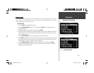
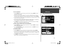
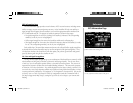
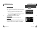
The GPS Information page provides a visual reference of GPS receiver functions, including current
satellite coverage, receiver status and position accuracy. As the StreetPilot III locks onto satellites, a
signal strength bar will appear for each satellite in view, with the appropriate satellite number (from
01-32) underneath each bar. The progress of satellite acquisition is shown in three stages:
• No signal strength bar: the receiver is looking for the satellite(s) indicated. The corresponding
number(s) on the sky view is not highlighted.
• Hollow signal strength bar: the receiver has found the satellite and is collecting data.
• Solid signal strength bar: the receiver has collected the necessary data and the satellite(s) is ready
for use. The corresponding number(s) on the sky view is highlighted.
Each satellite has a 30-second data transmission that must be collected (hollow signal strength bar,
as described above) before that satellite may be used for navigation (solid signal strength bar). Once
a fi x has been calculated, the StreetPilot III will then update your position, ground track and ground
speed by selecting and using the best satellites in view.
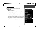
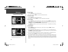
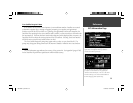
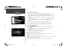
Sky View and Signal Strength Bars
The sky view and signal strength bars give you an indication of which satellites are currently visible,
which satellites are being used to calculate a position fi x and the signal quality. The sky view shows
a “bird’s eye” view of each satellite position relative to the unit’s last known position. The outer circle
represents the horizon in all directions (with cardinal heading references). The inner circle represents
an elevation of 45° above the horizon. Any satellite depicted near the center is directly overhead. You
can use the sky view to help determine whether any satellites are being blocked and whether you have
a current position fi x (indicated by ‘2D Navigation’ or ‘3D Navigation’ in the status fi eld). You can also
set the sky view to a ‘Track Up’ instead of ‘North Up’ confi guration (under the ‘Orientation’ fi eld of
the ‘Map’ tab page under ‘Map Setup’), causing the top of the sky view to align to your current track
heading.
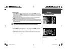
A hollow bar (number 17) indicates the receiver has
found the satellite and is collecting data.
Solid bars indicate the receiver has collected the
necessary information and the satellite is ready for use.
190-00256-10_0B.indd 37 1/13/2003, 10:34:02 AM