


18
Map Page Options
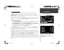
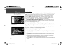
Like each of the main pages, the Map page is menu driven. With the Map page displayed, pressing
MENU will display an options menu, allowing you to customize the page to your preferences and/or
select special features which specifi cally relate to the Map page. To display the Map page options
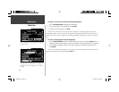
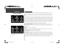
menu, press MENU (with the Map page displayed). The following options are available : ‘Show
Full Screen Map’ or ‘Show Map and Nav Info’, ‘Use Indoors’ or ‘Use Outdoors’, ‘Measure Distance’,
‘Select Layout’ and Map Setup’. These options are described in more detail below.
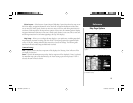
Show Full Screen Map (or) Show Map and Nav Info— ‘Show Full Screen Map’ removes all
screen information for the largest possible map display. ‘Show Map and Nav Info’ shows the map and
the navigation information for the current layout.
Use Indoors (or) Use Outdoors— The ‘Use Indoors’ option stops satellite reception, conserves
power usage, and speeds Map page drawing. The ‘Use Outdoors’ option listens to satellites for real-time
navigation.
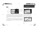
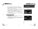
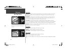
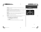
Measure Distance— Allows you to measure the distance between any two points you choose on
the Map page. Also displays the latitude and longitude of the pointer.
To measure the distance between two points:
1. From the Map page, press MENU.
2. Select ‘Measure Distance’ and press ENTER. An on-screen pointer will appear on the map display at
your current location.
3. Move the panning arrow to the desired reference point (the point you want to measure from) and
press ENTER.
4. Move the panning arrow to the second point, to which you want to measure. The direction and
distance from the reference point is shown on the top of the Map page.
5. Press the QUIT key or select ‘Stop Measure Distance’ on the menu to return to the regular Map page
display.
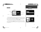
Reference
Map Page Options
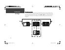
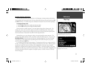
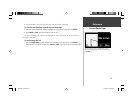
You can adjust the size of the map by using the ‘Select
Layout’ option.
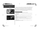
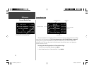
The Options menu on the Map page allows you to
customize the Map page.
190-00256-10_0B.indd 18 1/13/2003, 10:33:46 AM