


14
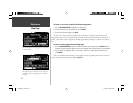
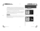
When you are not driving on roads that are present in the maps, you may see a circle drawn around
the position pointer. This is the ‘accuracy circle’. The StreetPilot III uses both map resolution and GPS
accuracy in defi ning your location to a point within this “accuracy circle”. The smaller the circle, the
more accurate your location. More detailed map features as well as information about those features
can be displayed using a data card containing map data transferred from a Garmin MapSource CD-
ROM. When you zoom into smaller map scales, “MapSource” will appear directly below the map scale
indicating that MapSource data is being used to draw a more detailed map.
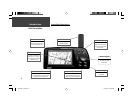
Map Page Navigation Information
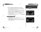
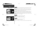
The following navigation information can be displayed on the Map page:
Current Direction (N, S, E, or W)
– Cardinal letters indicate the direction you are traveling when
not navigating a route.
Direction To Go (Arrow) – An arrow that points to the next turn in the route when moving on an
active route.
Speed
– Your rate of travel which can be displayed in miles per hour or kilometers per hour.
Distance To Go – When navigating a Route, the distance remaining to reach the next turn will be
displayed. When not navigating a Route, this fi eld is not displayed.
Time To Go – When navigating a Route, the time to go before reaching the next turn is displayed.
When not navigating a Route, the time for the current time zone is displayed in either 12 or 24
hour format.
Driving Instructions
– Given in text format only when you are navigating a route. When you are
not navigating, the next intersection is displayed.
Reference
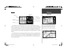
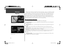
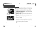
Map Page
Clear driving instructions are displayed when you are
navigating a route.
Your vehicle speed can be displayed in miles per hour or
kilometers per hour.
190-00256-10_0B.indd 14 1/13/2003, 10:33:43 AM