


46
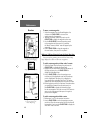
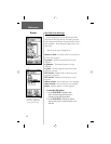
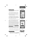
Units Page - Overview
The Units features are best used by individuals with
a working knowledge of map grids and datums. To learn
more about these subjects, visit the National Imagery
and Mapping Agency at http://www.nima.mil or inquire
at your library.
Position Format - Allows you to choose from
different grid formats. The default position format,
‘
hddd
o
mm.mmm’ displays the latitude and longitude
in degrees and minutes and is most commonly used.
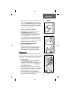
Map Datum - Offers a selection of nearly all map
datums in common use. Every map is based on a
map datum (a reference model of the earth’s shape)
and is usually listed in the title block of the map. If
you are comparing GPS coordinates to a paper map,
chart, or other reference, the map datum in this fi eld
must match the horizontal map datum used to gener-
ate the map or other reference. The default datum
is WGS 84 (World Geodetic Survey 1984) and should
only be changed when using maps or charts specifying
a different datum. If a map does specify a datum,
use the options list to fi nd datums applicable to the
region of the map, selecting the one that provides
the best positioning at a known point. You may also
choose the ‘User’ datum for custom designed grids.
Distance/Speed - You can choose from three units of
measure to display your rate of travel.
Elevation/Vertical Speed - You can choose from two
units of measure to record your elevation and rate of
ascent.
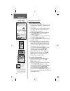
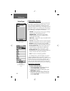
Step-by-Step Instructions
To select Units Page options:
1. For all fi elds on this page, highlight the fi eld and
then press in on the CLICK STICK to display the
options menu for the fi eld.
2. Highlight the desired option on the menu and then press
in on the CLICK STICK to place it in the fi eld.
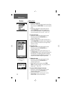
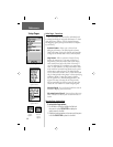
Setup Pages
Reference
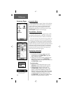
Units Page
Position Format
Options Menu
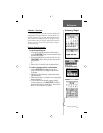
Map Datum
Options Menu
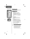
Distance/
Speed
Options
Elevation/
Vertical
Speed
Options