


GPSMAP 400/500 Series Owner’s Manual 7
Using Charts
Using Charts
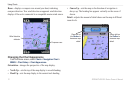
Your chartplotter has a worldwide basemap or BlueChart g2
cartography for either the USA shoreline or a specic country.
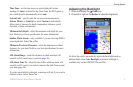
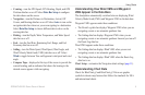
• —displays all relevant navigation data
available on your preloaded maps, including buoys, lights,
cables, depth soundings, marinas, and tide stations, in an
overhead view.
• —provides a view from above and behind the
boat (according to your course), and provides a visual navigation
aid.
• —displays two different zoom levels of
the Navigation chart at the same time.
Mariner’s Eye 3D charts and Fish Eye 3D charts are available
only if you use a BlueChart g2 Vision SD card. Fishing charts
are available if you use a BlueChart g2 Vision SD card or if your
built-in map supports Fishing charts.
• —provides a view of the chart with enhanced
bottom contours and without navigational data. This chart works
well for offshore deep-sea shing.
• —provides an underwater 3D view that visually
represents the sea oor according to the information on the chart.
• —provides a view from above and behind
the boat as a three-dimensional navigation aid. The BlueChart
g2 Vision Mariner’s Eye 3D is more detailed than the preloaded
data.
: If you are using a GPSMAP 421, 521, or 526 (including
“s” models), you must insert an optional BlueChart g2 Vision
preprogrammed SD card to view detailed Navigation and
Mariner’s Eye charts.
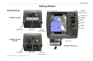
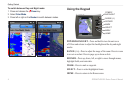
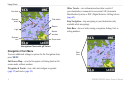
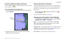
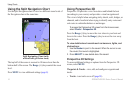
Using the Navigation Chart
Use the Navigation chart to plan your course, to view map
information, and as a navigational aid.
To access a Navigation chart, from the Home screen, select
Charts > Navigation Chart�