


v
A Word to GP-30/35 Owners
Congratulations on your choice of the
FURUNO GP-30/35 GPS Navigator. We are
confident you will see why the FURUNO
name has become synonymous with quality
and reliability.
For over 40 years FURUNO Electric Com-
pany has enjoyed an enviable reputation for
innovative and dependable marine electron-
ics equipment. This dedication to excellence
is furthered by our extensive global network
of agents and dealers.
Your navigator is designed and constructed
to meet the rigorous demands of the marine
environment. However, no machine can per-
form its intended function unless installed,
operated and maintained properly. Please
carefully read and follow the recommended
procedures for installation, operation, and
maintenance.
We would appreciate hearing from you, the
end-user, about whether we are achieving
our purposes.
Thank you for considering and purchasing
FURUNO equipment.
FOREWORD
Features
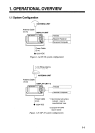
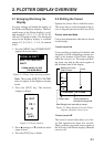
The GP-30/35 GPS Navigator is a totally
integrated GPS receiver and video plotter,
and consists of a display unit and an antenna
unit. The high sensitivity receiver tracks up
to eight satellites simultaneously. An 8-state
Kalman filter ensures optimum accuracy in
determination of vessel position, course and
speed.
The main features of the GP-30/35 are
• GP-35 has a built-in DGPS beacon re-
ceiver which improves position accuracy.
• A DGPS beacon receiver may be con-
nected to the GP-30.
• Comprehensive navigation data displays
• Storage for 350 waypoints and 30 routes
• Alarms: Arrival, Anchor Watch, Cross
Track Error and Ship’s Speed
• Man overboard feature records latitude
and longitude or LOP (Loran C or Decca)
coordinates at time of man overboard and
provides continuous updates of range and
bearing when navigating to the MOB
position.
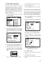
• Menu-driven operation
• Bright 95 x 60 mm LCD with adjustable
contrast and brilliance
• Power consumption is a low 3 W.
• Provision for connection of autopilot (op-
tion) – steering data output to autopilot
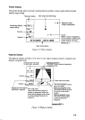
• Unique “Highway” display provides a
graphic presentation of ship’s progress to-
ward a waypoint.
• Own ship’s position may be shown in lati-
tude and longitude or LOP (Loran C or
Decca).
• Waypoint and route data can be uploaded
from a PC or downloaded to a PC.