


11-5
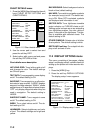
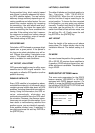
11.3 GPS/DGPS/TD OPTIONS
menu
This menu sets up GPS and DPGS receiv-
ers and enables display of position in Loran
C or Decca TDs.
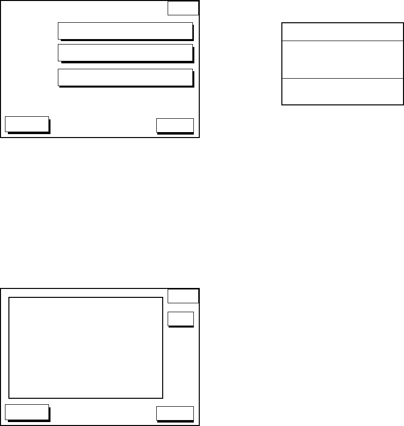
1. Press the [MENU] key.
2. Press the soft key GPS/DGPS/TD OP-
TIONS to display the GPS/DGPS/TD op-
tions menu.
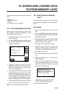
GPS/DGP
OPTION
DGPS 3D
GPS SETUP OPTIONS
TD SETUP
DGPS SETUP OPTIONS
RETURN
Figure 11-7 GPS/DGPS/TD options menu
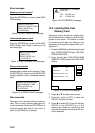
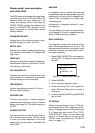
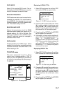
GPS SETUP OPTIONS menu
description
This menu provides items for setting up the
GPS receiver. To display it, show the menu
shown in Figure 11-7, and then press the soft
key GPS SETUP OPTIONS.
GPS
OPTION
DGPS 3D
RETURN
LOCAL TIME OFFSET +00:00
GEODETIC DATUMS WGS-84
POS SMOOTHING 000 sec
SPD/CSE SMOOTHING 005 sec
GPS SPEED AVE 060 sec
LAT OFFSET 0.000’N
LON OFFSET 0.000’E
DISABLE SATELLITE _ _ _ _ _ _
LATITUDE 38°00.000’N
LONGITUDE 123°00.000’W
ANT. HEIGHT 005 m
FIX MODE 2D/3D
s
EDIT
Figure 11-8 GPS SETUP options menu
LOCAL TIME OFFSET
GPS uses UTC time. If you would rather use
local time, enter the time difference between
local time and UTC time. Use the soft key
+<-->- to switch from plus to minus and vice
versa.
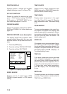
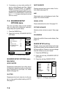
GEODETIC DATUM
Your equipment is preprogrammed with most
of the major chart systems of the world. Al-
though the WGS-84 system, the GPS stan-
dard, is now widely used other categories of
charts still exist. Select the chart system used,
not the area where your boat is sailing. The
default chart system is WGS-84.
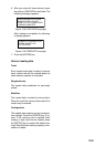
1. Select GEODETIC DATUMS.
2. Press the soft key EDIT to show the geo-
detic datum window.
GEODETIC DATUMS
CHART DATUM
▲
AUSTRALIA
▼
WGS-84
Figure 11-9 Geodetic datum window
3. Press ▲ or ▼ to select the chart system
you are using. If no chart datum exists for
geodetic datum selected UNKNOWN ap-
pears in the CHART DATUM window. In
this case select a different chart system.
4. Press the soft key ENTER or the [ENTER]
key to register your selection.
POS SMOOTHING
When the DOP or receiving condition is un-
favorable, the GPS fix may change greatly,
even if the vessel is dead in water. This
change can be reduced by smoothing the raw
GPS fixes. A setting between 000 to 999 is
available. The higher setting the more
smoothed the raw data, however too high a
setting shows response time to change in
latitude and longitude. This is especially no-
ticeable at high ship’s speeds. 000 is the
normal setting; increase the setting if the GPS
fix changes greatly.