


ii
FOREWORD ....................................... iv
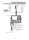
SYSTEM CONFIGURATION ....... v
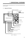
1. OPERATIONAL OVERVIEW
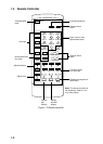
1.1 Display Unit Controls ....................... 1-1
1.2 Remote Controller ........................... 1-2
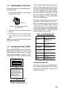
1.3 Inserting Mini Chart Card................. 1-3
1.4 Turning the Power On/Off ................ 1-3
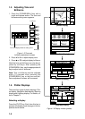
1.5 Adjusting Tone and Brilliance .......... 1-4
1.6 Plotter Displays................................ 1-4
1.7 Sounder Displays ............................ 1-5
1.8 Menu Operation, Soft Keys ............. 1-5
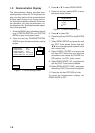
1.9 Demonstration Display .................... 1-6
2. VIDEO SOUNDER
OPERATION
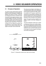
2.1 Principle of Operation ...................... 2-1
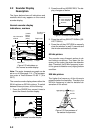
2.2 Sounder Display Description ........... 2-2
2.3 Plotter/Sounder Display................... 2-4
2.4 Dual-frequency Display ................... 2-4
2.5 Automatic Sounder Operation ......... 2-5
2.6 Manual Sounder Operation ............. 2-5
2.7 Measuring Depth ............................. 2-6
2.8 Suppressing Interference ................ 2-7
2.9 Suppressing Low Level Noise ......... 2-7
2.10 Erasing Weak Echoes ..................... 2-8
2.11 White Marker ................................... 2-8
2.12 Selecting Picture Advance Speed ... 2-9
2.13 Selecting Background and Echo
Colors .............................................. 2-9
2.14 Alarms ............................................ 2-10
2.15 Interpreting the Display................... 2-11
3. PLOTTER DISPLAYS
3.1 Presentation Modes......................... 3-1
3.2 Cursor .............................................. 3-2
3.3 Shifting the Display.......................... 3-2
3.4 Selecting Chart Scale/Range .......... 3-2
3.5 Mini Chart Cards.............................. 3-2
3.6 Navigation Data Display .................. 3-5
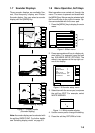
3.7 Steering Display .............................. 3-6
3.8 Highway Display .............................. 3-7
3.9 Changing Operation Mode .............. 3-8
3.10 Navigation Trip Distance ................. 3-8
4. TRACK
4.1 Displaying Track .............................. 4-1
4.2 Stopping/Restarting Plotting
of Track ............................................ 4-2
4.3 Changing Track Color ...................... 4-2
4.4 Track Plotting Method, Interval ........ 4-2
4.5 Changing Track Memory Capacity .. 4-3
4.6 Erasing All Track .............................. 4-4
5. MARK
5.1 Entering Marks ................................ 5-1
5.2 Changing Mark Attributes ................ 5-2
5.3 Changing Mark Size ........................ 5-3
5.4 Erasing Marks.................................. 5-4
5.5 Displaying Track and Mark Points ... 5-4
6. WAYPOINTS
6.1 Entering Waypoints .......................... 6-1
6.2 Erasing Individual Waypoints ......... 6-4
6.3 Changing Waypoint Data ................. 6-4
6.4 Waypoint Mark Size ......................... 6-5
6.5 Changing Waypoint Position on the
Plotter Display ................................. 6-5
6.6 Searching Waypoints ....................... 6-5
7. ROUTES
7.1 Entering Routes ............................... 7-1
7.2 Connecting Routes .......................... 7-2
7.3 Inserting, Removing Waypoints ....... 7-2
7.4 Creating Track-based Routes .......... 7-4
7.5 Erasing Routes ................................ 7-5
8. NAVIGATION
8.1 Navigating to “Quick Points” ............ 8-1
8.2 Navigating to Waypoints
(waypoint list) ................................... 8-2
8.3 Navigating to Ports, Port Services... 8-2
8.4 Following a Route ............................ 8-3
8.5 Cancelling Navigation ...................... 8-5
TABLE OF CONTENTS