


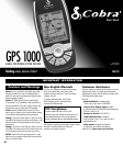
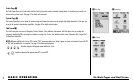

1.0 BASIC OPERATION
Making Travel Easier
Your GPS receiver makes travel easier through the following ways:
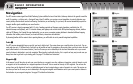
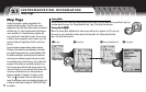
GoTo a Waypoint Ẅ – This GPS receiver guides you in a straight line to a single point.
GoTo a City/Town Ẅ– This GPS receiver is already programmed with hundreds of cities/towns worldwide and can guide you in a
straight line to a selected city/town.
NOTE: A city/town is much larger than the precise location indicated by the coordinates stored in your GPS receiver. See page 39 for details.
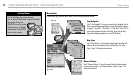
GoTo a Point of Interest, Address, Intersection or Exit ẅ– With optional computer software and an interface cable, this GPS
receiver can be connected to a computer to take advantage of powerful mapping programs and to transfer data back and forth between the
computer and your receiver. POI, addresses, intersections and exits transferred from a computer can be saved as waypoints to be used as
points within routes for navigation purposes or your receiver can guide you in a straight line to a selected POI, address, intersection or exit.
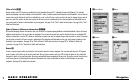
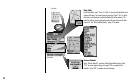
Navigate a Route Ẇ – This GPS receiver gives you the opportunity to select two or more points to create a route. You can then use your
GPS receiver to guide you in a straight line from point to point through your stored route.
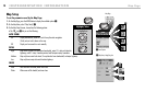
Navigate a Track ẇ– This GPS receiver automatically keeps a record of your progress as you travel and gives you a graphic
representation of a “track log” of the path or track you have taken. You can use the track log to create a track that you can recall for
navigation. The track can be navigated in the forward or the reverse direction of the original travel.
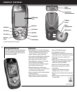
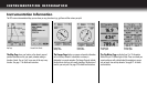
Your GPS receiver is already programmed with a Base Map that includes locations of hundreds of worldwide cities; U.S. state, Canadian provincial
and European country boundaries; U.S. interstate freeways, highways and exits; and land cover (inland bodies of water). By using the data
interface, optional SD memory card and optional mapping software, you can also download maps and points of interest from your computer.
The manual is designed to help you take advantage of these and many other features. We suggest that you begin by reading the “General
Information” and “Instrumentation Information” sections first. If you are not familiar with computer-based satellite navigation technology, these
sections will help you understand the basics.
ẆNavigate a Route ẇNavigate a Track
ẄẅGoTo a Waypoint, City/Town, Point of Interest, Address, Intersection
or Exit