


Apollo CNX80 Pilot’s Guide
38
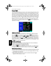
System Mode (SYS)
The System mode provides information about GPS status (GPS), Sys-
tem Software Versions (VERS), and allows for configuring the system
for individual installations (CNFG).
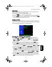
GPS Status
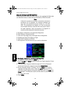
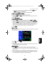
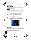
1. Press FN and then the SYS key to reach the System functions.
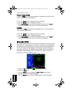
2. The GPS function shows a map of the satellite locations with ID and
other system information. On the right side of the display, a bar
graph is shown for each satellite ID.
WAAS: In use indicates WAAS corrections are being used. Standby
is shown if WAAS corrections are not being used.
Time: Current UTC time computed from the GPS constellation.
EPU: Estimated Position uncertainty in meters. Dashes are
shown if the value is not valid.
HPL: Horizontal Protection Level in meters. Dashes are shown if
the value is not valid.
VPL: Vertical Protection Level in meters. Dashes are shown if
the value is not valid.
Lat/Lon: Current position in degrees, minutes, and hundredths of
minutes.
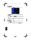
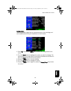
Software Versions
The Software Version page shows you the serial number for the CNX80
and the versions of the software in your unit. This information is useful
should you need to talk with Technical Support at Garmin AT. Please
copy the values for the information on this display before calling
Garmin AT Technical Support (1-800-525-6726).
System
CNX80 Pilot Guide 560-0984-00C Draft1.book Page 38 Tuesday, September 2, 2003 10:36 AM