


5-EN
EN
ALPINE NVD-A802 68-06194Z86-A (EN)
Preface
Navigation Terminology
Navigation
The navigation system displays and tracks the vehicle’s
position and movement on a moving map display. When a
destination is input, the navigation system quickly
calculates a route and guides you along the route with
pictorial displays and voice prompts.
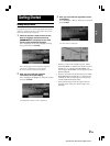
Present Vehicle Position Indicator
The present vehicle position is indicated by an arrowhead
within a circle
Map matching
Since GPS navigation has an error window of about 100 –
650 feet (30 m – 200 m), the position of your vehicle may
be calculated in such a way that it is displayed incorrectly
off the road. Map matching automatically corrects this error
so that the position is displayed on the road.
Destination
The destination point is represented by a bullseye icon.
Address Book
Up to 300 personal locations and phone numbers can be
stored in the system’s memory.
Popular Points of Interest
Fourteen different POI icons can be displayed on the map.
These icons indicate the locations and names of the
nearest gas/fuel stations, restaurants, parking garages,
parking lots, ATMs, banks, convenience stores, grocery
stores, freeway exits with IA data, hotels & motels, bed &
breakfast, post offices, hospitals and schools. All 14 icons
can be displayed on the screen at one time.
•The brand icons appear on the map. For details, see page
63 of this Manual.
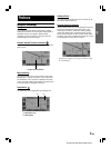
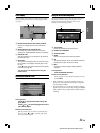
a Destination icon
b Route (Blue)
Present vehicle position
a
b