


10-EN
ALPINE NVD-A802 68-06194Z86-A (EN)
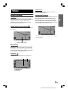
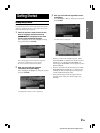
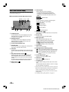
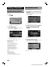
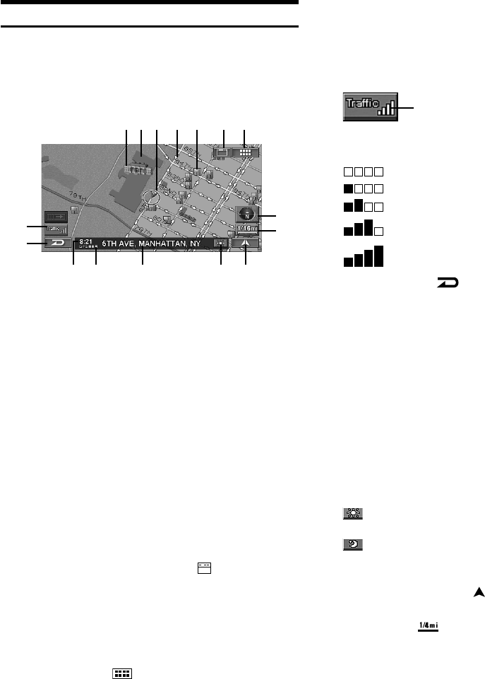
How to View a Current Display
The navigation map screen usually displays the current vehicle
position and surrounding area.
L Current Vehicle Position Map (without route)
a Landmark Icons
The 3D landmark icons can be displayed on the map
when map scale is 1/16 mile (100 m) or less, see
“Landmark Icons” (page 64).
b Building Outlines
The building outlines can be displayed on the map
when map scale is 1/16 mile (100 m) or less, see
“Building Outlines” (page 64).
c Current vehicle position icon
d One Way Icon
The one way icons can be displayed on the map when
map scale is 1/16 mile (100 m) or less.
e POI Icons
The POI icons can be displayed on the map when map
scale is 1/8 mile (200 m) or less, see “POI Icons” (page
62).
f Main Source Screen button ( )
Displays the main source screen of the Alpine touch
panel-compatible monitor. For details, refer to the
Owner's Manual of the Alpine touch panel-compatible
monitor.
If a monitor other than Alpine touch panel-compatible
monitor is connected, this button cannot be used.
g MENU button ( )
Displays the Nav Menu.
h Traffic button*
Traffic Incident List screen is displayed.
* If the XM Data Receiver HCE-100XM (sold
separately) or the SIRIUS Data Receiver (sold
separately) is connected, the traffic button can be
used.
If Traffic & Weather is received, signal strength is
indicated by a 4-bar icon type display.
(No Signal)
(Weak Signal)
(Marginal Signal)
(Strong Signal)
(Very Strong Signal)
i Cancel button ( )
Cancels the current screen and returns to the previous
menu screen.
j Current Time
Current time received from GPS signals.
k GPS signal state
GPS signal strength (indicated by a dot).
GPS: No satellite information is being received.
GPS L: Current position is being calculated.
GPS LL: GPS signal 2-D is being received.
GPS LLL: GPS signal 3-D is being received.
l Street name
Name of the current street.
m Day/Night Screen Switching button
: The icon is displayed when the day screen is set.
Touching this icon will switch to the night screen.
: The icon is displayed when the night screen is
set. Touching this icon will switch to the day
screen.
n Current Map button ( )
Returns to the current position screen.
o Scale Icon ( )
Map scale is shown. (see page 12)
p Compass Icon
Indicates North, heading and 3-D mode on the current
map.
The arrowhead shows the direction of north. To change
the map orientation, see page 13.
•When powering on the unit for the first time, it takes the
GPS receiver approximately 10 minutes to calculate the
vehicle’s current position. During this period, the
vehicle position icon may not move even if the vehicle
is being driven.
•For displays during route guidance, see page 37.
System Status
d
c
p
o
n
j
k
l
e
b
a
h
fg
i
m