- 23 -
Menu Options
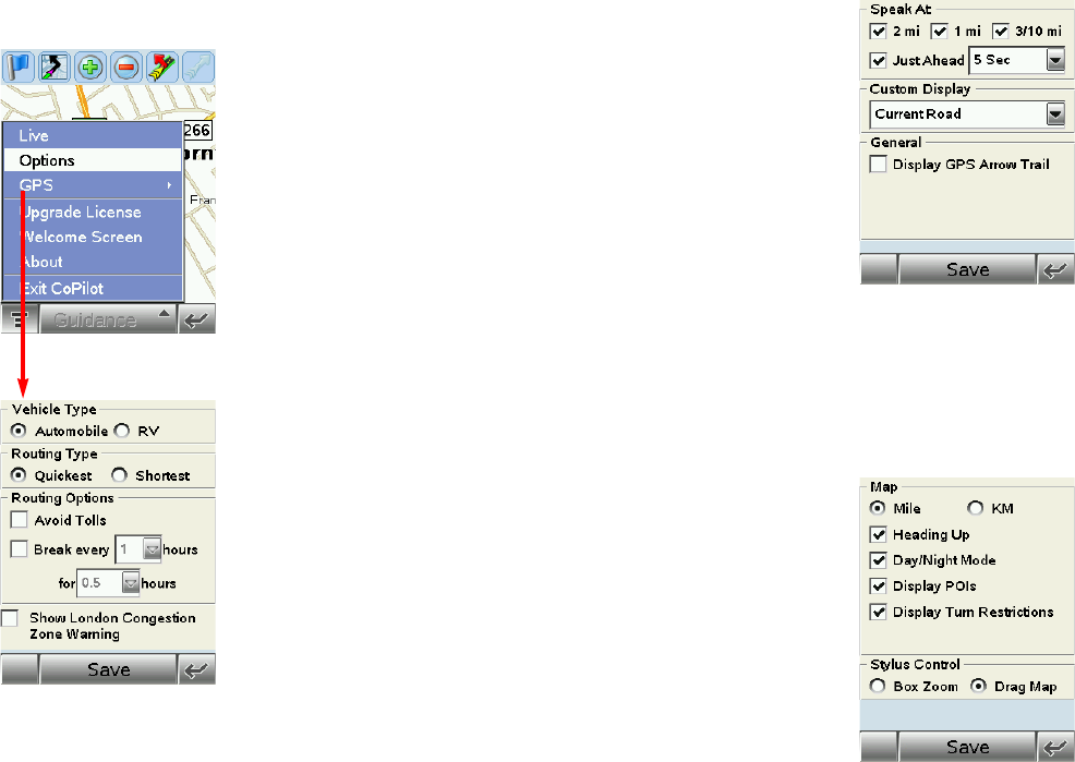
Tap the top of either the Map Screen or the Driver Safety
Screen to access the menu bar. Then tap Menu and select
Options.
Routing
In the Routing tab, the vehicle type options are
Automobile or RV. RV routes favor major roads and
avoid sharp turns and U-turns wherever possible.
The Quickest routing type is based on the most practical
route in terms of road quality, terrain, and urban/rural
classifications. Shortest routing travels the least distance
where possible while maintaining some level of practicality.
More routing options are:
Avoid Tolls — Check to avoid tolls wherever possible and practical.
Break every ___ hours for ___ hours — Check to have the ETA for your trip adjusted to
reflect stops for breaks.
Display Congestion Zone Warning — (United Kingdom only) Check to have CoPilot
provide a warning when your trip will pass through a congestion zone (gives you the option
to route around it) or when your destination is within a congestion zone (gives you the
option to continue after warning).
- 24 -
Guidance
In the Guidance tab, the settings under Speak Turn
Warning At determine how often and where CoPilot will
give you next turn information out loud. All, none, or some
boxes can be checked. A pick list gives the options for Just
Ahead: by default you will be alerted 5 sec/100 ft before
every turn (5 seconds or 100 feet, whichever is closest),
but you can choose to have CoPilot speak to you sooner
(2 -8 seconds before each turn, or 100 feet).
The pick lists under Custom Display give you display
options for the line above the ETA in the Driver Safety
screen. This line can display the current road, nearest
crossroad, nearest major road, nearest town, ETA, or speed.
NOTE: Defaults are set here, but you can also toggle through the options by tapping the line
itself in the Driver Safety Screen.
Tick Display Route Arrow to have a yellow turn arrow appear on your route on the map as
you approach each turn (this option is turned on by default). Tick Display GPS Arrow Trail
to keep a trail of arrows that tracks your position as you drive on the map.
Map
Data areas that are currently downloaded to your mobile
device are shown at the bottom of this screen.
Options in the Map tab are:
Mile — Use miles as the unit of distance.
KM — Use kilometers as the unit of distance.
Heading Up — The map display will always track your
position moving upward.
North Up — The map display will always maintain north at
the top as you drive.
Box Zoom — This option is selected by default. It enables you to zoom into an area on the
map by drawing a box around it with the stylus.
Drag Map — Selecting Drag Map lets you use the stylus to drag the map in any
direction to a desired location. Place the stylus on the map and move it across the screen.
Use the tick boxes for automatic Night Mode display from early evening to early morning,
and to display Points of Interest, and to display turn restrictions.


