


PinPoint-E EDGE/GPRS - User Guide, version 2.32 137
GPS Message Format Streams
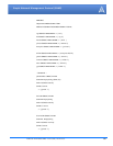
Example taken from PinPoint-E output:
$GPRMC,173219.428,A,3505.1436,N,08037.5669,W,0.09,13.55,040403,,,*2B
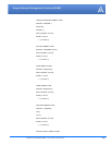
Example taken from PinPoint-E output:
$GPVTG, 308.49,T,,M,0.05,N,0.1,K,*62
Units of geoidal separation, meters M
(not applicable to the PinPoint-E) null field
Differential reference station ID, 0000-1023 0000
Optional checksum field consisting of "*" and
two hex digits.
Represents the exclusive OR of all characters
between, but not including, the "$" and "*".
*1E
TABLE 2. RMC - Recommended Minimum Navigation Information
Description Field Contents
Global Positioning System (GPS) GP
Recommended Minimum sentence C Phase RMC
UTC (Fix taken at 17:32:19 UTC) 173219.428
Status A=Active or V=Void
(A status of V indicated the GPS has a fix that is
below an internal quality threshold, i.e. dilution
of precision is too high or an elevation mask test
failed)
A
Latitude 3505.1435
North or South N
Longitude 08037.5669
East or West W
Speed over ground, knots 0.09
Track angle in degrees True 13.55
Date (04th of April 2005) 040405
Magnetic Variation, degrees null field
East or West null field
Checksum *2E
TABLE 3. VTG - Vector track and Speed over the Ground
Description Field Contents
Global Positioning System (GPS) GP
Track made good and Ground speed VTG
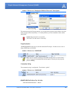
TABLE 1. GGA - Global Positioning System Fix Data
Description Field Contents