


PinPoint-E EDGE/GPRS - User Guide, version 2.32 136
APPENDIX E GPS Message Format Streams
This appendix shows the GPS message streams provided by the PinPoint-E.
NMEA Message Description
The standard GPS data stream provided by the PinPoint-E in raw serial (ASCII) format is com-
prised of (3) GPS NMEA receiver messages (“sentences”): GGA, RMC and VTG. All NMEA
messages start with a dollar sign ($) followed by a message type identifier. After the identifier, the
fields of the messages are comma deliminated.
Example taken from PinPoint-E output:
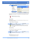
$GPGGA,173221.428,3505.1435,N,08037.5669,W,1,04,2.2,242.9,M,46.9,M,,0000*1E
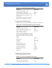
TABLE 1. GGA - Global Positioning System Fix Data
Description Field Contents
Global Positioning System (GPS) GP
Global Positioning System Fix Data GGA
UTC (Fix taken at 17:32:21 UTC) 173221.428
Latitude 3505.1435
North or South N
Longitude 08037.5669
East or West W
Fix Quality
(0=invalid, 1=GPS fix, 2=DGPS fix)
1
Number of satellites being tracked 04
Horizontal dilution of precision (metres) 2.2
Antenna altitude above/below mean-sea-level
(geoid)
242.9
Units of antenna altitude, meters M
Geoidal separation, the difference between the
WGS-84 earth ellipsoid and mean-sea-level
(geoid)
"-" means mean-sea-level below ellipsoid
46.9