


Page 105
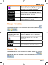
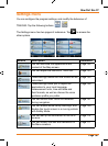
How Do I Use It?
• Taxi
• Bus
• Emergencyvehicles
• Bicycle
• Pedestrians
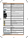
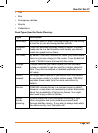
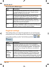
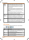
Road Types Used for Route Planning:
Type Description
Motorways You might need to avoid motorways when you are driving
a slow car or you are towing another vehicle.
Unpaved
roads
TRAX353 excludes unpaved roads by default: unpaved
roads can be in a bad condition and usually you cannot
reach the speed limit on them.
Toll roads By default TRAX353 includes toll roads (pay roads where
there is a per-use charge) in the routes. If you disable toll
roads, TRAX353 plans the best toll-free route.
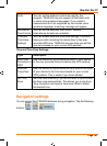
Charge
roads
Charge roads are pay roads where you can purchase
a pass or vignette to use the road for a longer period of
time. They can be enabled or disabled separately from
toll roads.
Permit
needed
You might need a permit or permission from the owners
to use certain roads or to enter certain areas. TRAX353
excludes these roads from the route calculation by
default.
Ferries TRAX353 includes ferries in a planned route by default.
However, a map does not necessarily contain information
about the accessibility of temporary ferries. You might
also need to pay a fare on ferries.
Cross-
border
planning
In some cases the route calculated according to your
other navigation and route preferences would lead
through another country. If you wish to always stay within
the same country, turn this option off.