


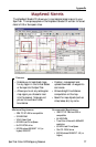
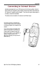

SporTrak Color GPS Mapping Receiver 85
Appendix
Latitude The angular distance north or south of the equator mea-
sured by lines encircling the earth parallel to the equator
from 0˚ to 90˚.
LAT/LON Coordinate system using latitude and longitude coordinates
to define a position on the earth.
Leg (Route) A segment of a route that has a starting (FROM) waypoint
and a destination (TO) waypoint. A route may consist of 1
or more legs. A route that is from waypoint A to waypoint
B to waypoint C to waypoint D has three legs with the first
being from waypoint A to waypoint B.
Longitude The angular distance east or west of the prime SporTrak
(Greenwich SporTrak) as measured by lines perpendicular to
the parallels and converging at the poles from 0˚ to 180˚.
Magnetic North The direction relative to a magnetic compass.
NMEA National Marine Electronics Association. A professional
organization that defines and maintains the standard serial
format used by marine electronic navigation equipment and
computer interfaces.
OSGB A coordinate system describing only Great Britain, similar to
UTMs. Used with GRB36 datum.
Position fix Position coordinates as computed by the SporTrak.
SOG Speed Over Ground. The speed at which the receiver is
moving.
TMP Temperature.
Tr ue North The direction to North Pole from an observer’s position.
The north direction on any geographical SporTrak.
UTC Universal Time Coordinated. Formerly referred to as
Greenwich Mean Time (GMT).
UTM Universal Transverse Mercator metric grid system used on
most large and intermediate scale land topographic charts
and maps.
VMG Velocity Made Good. The component of the velocity that is
in the direction of the destination.