


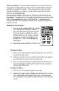

Deleting a Base Map or a Detailed Map
1) From any screen, press the Menu key. Use the up or down arrows to
highlight “Map Utilities” and press the Enter key.
2) Use the up or down arrows to highlight “Delete File” and press the
Enter key.
3) A list of all the maps that have been uploaded to your SporTrak Color
receiver is displayed. Use the up or down arrows to highlight the map
you want to delete from memory and press the Enter key.
4) A pop-up confirmation window is displayed. To continue with the
delete process, use the right or left arrow to highlight the “Yes” button
and press the Enter key.
5) Whether you selected Yes to continue with the delete process, or No
to cancel the delete process, you will be returned to the screen you
were viewing when you accessed the Map Utilities function.
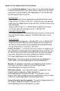
Navaids. The SporTrak Color now provides mariners with navaids added to their
waypoint database. These navaids can be used as any other waypoint and are easily
accessed through the Database function of your SporTrak Color receiver.
Tides and Currents. SporTrak Color users can now access tide information for
ports that are stored in their basemap. If a chart from one of the Magellan
MapSend BlueNav products has been uploaded, additional tide and current infor-
mation can be displayed for ports/stations that were included with the chart.
(Please note that not all MapSend BlueNav charts contain station information.)
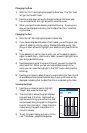
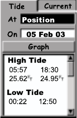
The Tide Screens. The Tide screen displays the times for high and low tides, the
water height and the coefficients (French internal ports only) for a selected date
and port. The displayed water heights are the height of the water at the lowest
astronomical tide. These values are provided as a rough guide and may vary with
weather conditions.
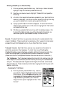
Accessing the Tide Screen
1) From any screen, press the Menu key. Use the
up or down arrows to highlight “Tide” and press
the Enter key. When a MapSend BlueNav chart
is uploaded and has been selected as the detailed
map (see Selecting a Base Map or a Detailed
Map) the menu option displayed will be “Tide/
Current”.