


Chapter 4: Setting Up the GPS Plotter 4-9
Chart Orientation
The plotter orientation is normally North Up, but can be changed to
Course Up or Head Up if heading data is available. The orientation
modes give the following displays:
• North Up: The screen is displayed with north upwards. As you
change heading, the ship’s heading marker moves. This is the default
mode and is the only mode available if there is no heading data.
• Course Up: The plotter is stabilized and displayed with the currently
selected course upwards. If you select a new course, the picture
rotates to display the new course upwards.
The reference used for the Course Up depends on the information
available. The first available in the following is used:
• A locked heading over a SeaTalk connection
• The heading at the time Course Up was selected
To update the Course Up reference whilst Course Up is the current
mode, re-select Course Up from the set up menu.
• Head Up: The display shows the vessel’s current heading upwards.
As the heading changes the image will rotate.
Waypoint Symbols
This setting controls whether or not the waypoints are shown on the
display, with their appropriate symbols. The active waypoint, and
waypoints in the current route, are always shown.
Waypoint Numbers
This setting controls whether or not the waypoint numbers are shown for
any waypoints in the current route.
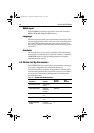
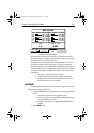
HEADING VECTOR OFF, 3 MINS,
10 MINS
INFINITE
OFF
COG VECTOR OFF, 3 MINS,
10 MINS
INFINITE
OFF
TIDE VECTOR OFF, 10 MINS, 1
HOUR
INFINITE
OFF
DATUM SELECTION WGS 84, LOCAL WGS 84
Parameter Options
Factory
Default
New
Default
81171_4.BOOK Page 9 Thursday, November 29, 2001 11:34 AM