


Index xiii
GPS Antenna 4
NMEA
10
System Checks
14
Integrated System
21
J
Joining a Route
33, 35
K
Keys
Dedicated
2, 7
Soft
2, 7, 5
L
Lighting Controls
3
List of Abbreviations
1
Log, Data
11
Loran TDs
12, 14
M
Managing
Database Lists
37
Tracks
39, 42
MARK Key
13, 17, 38, 44
MENU Key
40, 1
Menu, Pop-up
8
MOB
44
Alarm
44
Cancel
45
Data Box
44
Symbol
44
Waypoint
44
Mounting Template
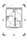
Antenna
1
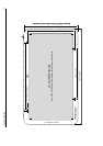
Display Unit
3
Moving a Waypoint
12, 20, 21
MSAS
v
see also WAAS
N
Name
a Route
21, 25
a Waypoint
12, 18
Navigation Data Pages
4, 3
Navigation Status Screen
11
NMEA
10
O
Off Track Alarm
45
Operating Controls
5
Soft Keys
5
Trackpad
6
P
Panning
6
Parts and Accessories
3
Placing a Waypoint
12, 13, 23
Plotter Set Up
8
Pop-up Menus
8
Position a Waypoint
12, 18
Position Data
44
Positional Accuracy
11
POWER Key
Switching Off
3
Switching On
1
Power-On Reset
2
R
RANGE Key
7
Registering this Product
3
Remote Cursor Echo
47
Chart
7
Radar
7
Removing a Waypoint
21, 32
Reset System
see System Reset
Restart GPS
13
Restart XTE
32, 36
Retrieving a Route
21, 29
Reversing a Route
32
Route
Clearing
21
Creating
21, 22
Current
21
Data Display
21
Database List
20, 21, 25
Deleting
21, 30
Editing
21, 30
Erasing
21, 30
Follow
33, 34
Following
32
81171_4.BOOK Page xiii Thursday, November 29, 2001 11:34 AM