


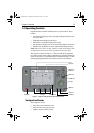

1-4 Raynav 300 GPS Plotter
Plotter Functions
Display Functions
The Raynav 300 GPS Plotter includes the following functions:
• Place, Move, Erase and Edit a Waypoint
• Goto Waypoint or Cursor
• Create, Save, Name, Edit and Follow a Route
• Review Route and Waypoint Lists
• Display vessel’s track; Save and Name the Track for re-call to screen
• Use SmartRoute to make the current track into a route
• Set Up Alarms and Timers
• Man OverBoard (MOB) to navigate back to a missing person or
object
• Data Log display
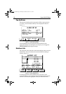
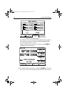
GPS Data Pages
Amongst a number of information pages, the GPS Data pages provide a
series of four textual displays, selected by the associated soft key. These
provide essential information associated with plotting a course for your
vessel.
• Fix status
• Steering Indication
• Position Latitude/Longitude
• Waypoint Bearing and Range
• Course Over Ground (COG)
• Speed Over Ground (SOG)
• Current Time
• Sunrise and Sunset Times
• Twilight Times
The range of pages is detailed in Selecting the Display Mode on page 2-4.
The complete range of pages is described fully in Data Display Pages on
page 3-2.
81171_4.BOOK Page 4 Thursday, November 29, 2001 11:34 AM