


EchoMap v3.0
63
Magnetic North: The region, some distance from the geographic
North Pole where the earth’s magnetic lines concentrate. The angle
between where the magnetic compass points to, magnetic north, and true
north is the magnetic variation. Magnetic variation is measured in east or
west. To get true course from magnetic course eastern variations are
deducted and western variations are added. In EchoMap, magnetic
deviation is calculated based on the nearest airport or Navaid. A light, thin
green tick on the compass indicates true north.
Minute: 1/60th of a degree of a circle. One nautical mile.
Nautical Miles (Nm): 1.15 statute miles equals 1 nautical mile. All
distances in EchoMap are in nautical miles.
NDB (Non-Directional Beacon): NDBs can be set to display, or not
display in the moving map mode according to their distance from the
aircraft; this is user configurable. NDBs, closest to furthest can also be
accessed directly through the D? /F5 and INFO/F2 keys.
Rng (Range): The distance from the present position to the destination
Waypoint measured in nautical miles.
Second: 1/60th of a minute of a circle.
Statute Mile: 0.87 of a nautical mile. Not currently used in EchoMap.
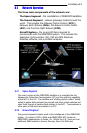
Subscriber Communicator (SC): The subscriber communicator is
the unit that simultaneously handles all two-way ORBCOMM data
transmissions as well as the receiving of GPS signals and sends all data via
an RS-232 serial port to the computer.
Trk (Track): The line over the earth that the aircraft is actually traveling.
True North: Geographic north, located at the North Pole.
True north is
represented in EchoMap by light green compass tick.
UTC (Universal Coordinated Time): Zulu time, the time in Greenwich,
England. This time, provided by the GPS is used to calculate weather age
in EchoMap.
Waypoint: Any fix used for navigation and defined by latitude and
longitude coordinates.