


EchoMap v3.0
39
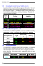
7.1 Data Link Weather vs. Onboard Radar
Data Link Weather is different from onboard weather radar in
several important ways.
Onboard Radar
Has the advantage of providing instantaneous information on
echo returns in front of the aircraft, making it ideal for
tactical
decision making while in close vicinity of thunderstorms.
Has the disadvantage of not being able to detect storms at a
distance. Additionally, it has problems seeing through a cell
to let you know what is beyond that echo due to attenuation.
Data Link Weather
Has the advantage of providing the big picture of NexRAD
Doppler radar activity for several hundred nautical miles
ahead, making it ideal for strategic flying.
Has a slight time delay due the fact the NWS provides
updates once every 5 minutes. Any data link information is
near real-time (typically no more than 5-10 minutes old on
average) but not
instantaneous and should never be used for
tactical weather avoidance. It should be used for strategic
weather avoidance only.
The addition of Metar weather provides the pilot with a much
greater awareness of various weather conditions at the
airports with types of information not available via onboard
radar.
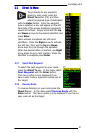
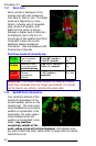
7.2 NexRAD Weather Radar
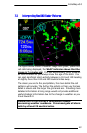
NexRAD weather is collected from the National Weather Service
and compiled into a composite image. This image contains
colored cells that represent precipitation (snow, rain or hail)
falling
in a particular area. The color of the cell represents the highest
level of precipitation registered at the time of the image.
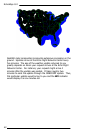
There are approximately 120 NexRAD stations in the US that are
combined to create the NexRad composite. The
map below shows
the approximate coverage of the Nexrad data. The map is subject
to change as NexRAD stations are added or change. Areas
without NexRAD coverage are shown as White.