


EchoMap v3.0
21
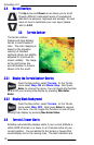
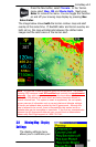
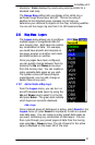
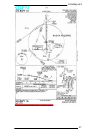
situations. Color displays the roads using coloring similar to a
standard road map.
The Range Ring setting lets you display a thin white ring a
particular range around your aircraft. This can be using in
addition to the standard green compass ring to help you
determine your di
stance to objects on the map, including weather.
You can set the range ring size from 5 to 100 nautical miles.
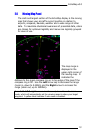
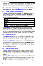
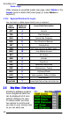
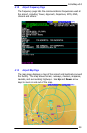
3.10 Map Menu - Layers
The Layers menu allows you to configure
multiple pages of navigational data for
your moving map. Each page can contain
any combination of data. For example,
you could have airports and airspace on
one page, airways on another and roads
and state borders on another.
Once you pages have been configured,
you can quickly change between them by
pressing the Up and Down arrow keys
from the moving map. You can create as
many separate data pages as you wish.
The system comes with several layers
preconfigured, you can add, change or
delete these as you wish.
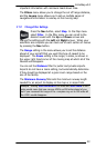
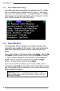
3.10.1 Add or Delete a Map Layer
From the Layers menu, you can turn on
and off individual data layers by using the
Up and Down keys to select it in the list
and press Enter. The green dots indicate
which layers are currently displayed.
Add a Layer
Once a desired group of data layers is active, select Insert in the
Layers menu (or press Insert on keyboard) to add as a preset
map data page. You can create as many preset data pages as
you want, containing any combination of data layers. You can
then cycle through your preset pages of data from the moving
map using Up + Down arrows. The list of layers for the active
page is displayed on the lower left of the map.