


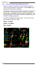

EchoMap v3.0
62
A
A
P
P
P
P
E
E
N
N
D
D
I
I
X
X
B
B
:
:
G
G
L
L
O
O
S
S
S
S
A
A
R
R
Y
Y
ALT (GPS Altitude): Altitude, calculated by the GPS receiver. A substantial
difference between this altitude value and altitude referenced above sea
level may exist due to accuracy degradation by the military; altitude
information should not be used for vertical navigation.
Azimuth: Bearing, as measured clockwise from true or magnetic north.
Brg (Bearing): The direction to any point, usually measured in 360
degrees relative to true or magnetic north.
Course: The planned direction of travel in a horizontal plane.
Course Deviation: The amount of distance left or right from the
desired course of travel.
CDI (Course Deviation Indicator): Is the graphic indicator of course
deviation shown as a graduated bar indicating the distance left or right of
course.
DTK (Desired Track): The desired course of navigation between a point
of origin and a destination Waypoint.
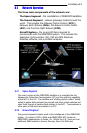
GES (Ground Earth Station): The ground earth station links with the
ORBCOMM satellite to provide a direct link to the ORBCOMM Network
Control center.
GS (Ground Speed): Speed of travel across the ground measured in
nautical miles per hour.
INT (Intersection): Intersections can be set to display, or not display in
the moving map mode according to their distance from the aircraft.
Kts (Knots): All speeds are displayed as knots or nautical miles per hour.
Every 1.15 statute miles per hour equals 1 knot.
Lat (Latitude): Lines that circle, and are parallel to, the equator.
Latitude is in degrees, minutes and seconds north and south of the
equator.
LEO (Low Earth Orbit): A new generation of satellite communication
satellites orbiting at low altitude (approximately 500 miles above the
earth), able to communicate with low power ground transceivers without
the need for a directional antenna. All two-way data is transferred via
ORBCOMM’s Low Earth Orbit constellation.
Lon (Longitude): Any line from pole to pole measured in degrees,
minutes and seconds that is perpendicular to the equator.
METAR: the international standard code for hourly and special surface
weather observations. The METAR acronym roughly translates from the
French as Aviation Routine Weather Report.