


EchoMap v3.0
41
7.2.1 Requesting a NexRad Image
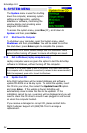
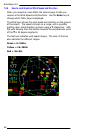
To request a NexRAD weather picture, press the WX
key and select NexRad in the menu. If the current
request settings are correct, simply press the Enter
key.
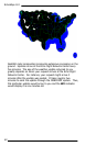
If you are connected to the
satellite transceiver, the request
will be sent to an ORBCOMM
satellite and relayed to Echo Flight
where a compressed data packet
of weather will be sent back to you
via satellite. The satellite status
indicator shows the current state
of this process. (See section 2.5).
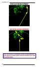
The NexRad layer will
automatically display on the map when received. This layer can
be toggled on and off by pressing Enter from the map.
Note: In Demo mode the NexRAD process is simulated.
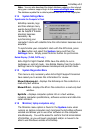
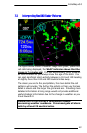
7.2.2 Changing NexRad Request Range
Select the Range option to set the diameter of the weather
request area. Use the Left and Right keys to decrease or
increase the range from 75 and 500 Nm in 25 Nm increments. In
order to optimize your request, select only the range you require.
(i.e. the distance to the next Waypoint). Transaction times can
increase with larger requests. The server may also be able to
provide higher definition pictures if smaller request ranges are
used.
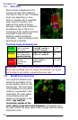
7.2.3 Changing NexRad Request Direction
There are two NexRAD request modes, 360 and Ahead. The 360
mode is for those times when you may want a full 360-degree
NexRAD picture centered on your current position. Remember
that in 360 mode the request range is roughly half the forward
distance. The Ahead mode extrapolates the request from your
current GPS location toward your target Waypoint so that most of
the picture will be situated ahead of you, with only a portion
behind you. The Ahead mode does not require you to be flying
toward the requested Waypoint.