


EchoMap v3.0
37
7
7
.
.
D
D
A
A
T
T
A
A
-
-
L
L
I
I
N
N
K
K
W
W
E
E
A
A
T
T
H
H
E
E
R
R
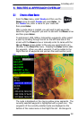
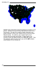
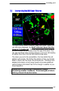
One of the most powerful features of EchoMap is Data Link Weather
using the ORBCOMM satellite constellation. The network operates
similar to a paging system in that it transmits and receives relatively
small compressed data packets in quick bursts.
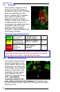
How to use Data Link Weather
• Data Link Weather provides supplemental information only.
It shows you the big weather picture for your route of flight.
• Data Link Weather is intended to augment, not replace,
pilot voice communication with Flight Service Stations (FSSs),
Air Traffic Control (ATC), or Airlines Operations Control
Centers (AOCCs).
• Despite common industry references to “real time weather”,
no data link weather is truly instantaneous. US government
NexRAD images are updated on average every 5 minutes,
and the average age of EchoMap Data Link Weather typically
ranges between 5 to 10 minutes by the time it reaches the
cockpit.
• Data Link Weather enables the user to efficiently
circumnavigate entire areas of bad weather, without having
to maneuver within close proximity of weather cells, reducing
time and fuel consumption in route.
• Data Link Weather provides an additional layer of
information, increasing the chance for breaking a link in the
chain of events that could potentially lead to an accident.
DO NOT use Data Link Weather to:
• Replace your pre-flight weather briefing.
• Replace other in-flight sources of weather data
such as Flight
Service Stations, ASOS, ATIS, weather radar and lightning
detection systems.
• Perform tactical flying in or close to storm activity.
• Chase storms!
Note : You must have either a Panasonic or Quake satellite transceiver
and subscription to Echo Flight to use any Data Link functionality.