


EchoMap v3.0
15
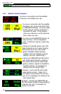
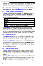
Map - The map menu lets you customize the display options for the
moving map, including which layers of navaid data are displayed on the
map as well as filtering options.
Routes - The routes menu lets you create user defined routes and
waypoints.
GPS Settings - The mode menu lets you select whether the display
is in demo mode, GPS mode or playback. The default normally selects
GPS mode.
System - The System menu provides access to system
configuration and diagnostics, the operating system, and the
system shutdown/exit options.
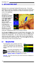
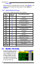
3.2 Demo Mode
To most easily learn how to use Echomap before
flight it is suggested you operate the display in demo
mode. To operate in demo mode, First press the Nav
key ,Then scroll down to GPS Settings and press Enter. Next
scroll down to Demo and press Enter.
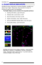
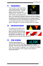
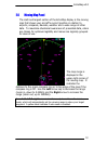
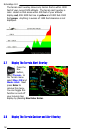
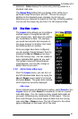
3.3 Map Range Controls
The Range keys? change your viewing range,
the left arrow decreases range and right
arrow
increases range. The range is displayed
in nautical miles in the upper right hand corner box of the moving
map indicating the distance of your aircraft to the edge of the
green compass ring.
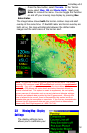
The viewing range will zoom down to .25 Nm and up to 2,500
Nm. Zooming closer than .25 Nm or Zooming farther than 2,500
Nm will cause the software to Enter into an auto-zoom function.
In the auto-zoom mode, the software will automatically make
the viewing range equal to the distance to your target waypoint.