


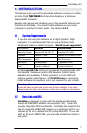


EchoMap v3.0
10
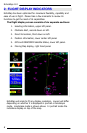
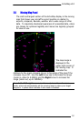
2.4 Position Indicators
Directly below the direct to indicator is
the navigation box. This box displays
current navigational information during
flight. The first two lines are Distance
to the Waypoint and Ground Speed.
The third line displays the Estimated
Time Enroute (ETE) to the target
waypoint. ETE is computed on your
actual track and closure rate, (not just
distance divided by ground speed), to
give you an extremely accurate time.
For this reason, the ETE indicator will disappear when your track is
90 degrees or more off from the target heading.
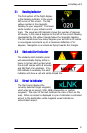
The final line indicates your altitude in feet above mean sea level.
This altitude will appear in yellow when your aircraft is 500-1000
feet above the terrain and red when within 500 feet or less. When
GPS reception is less than 4 satellites no altitude is displayed and
you will receive a No Alt warning in the Obstacle clearance panel.
Note: Although government Selective Availability has been removed, the
system is not to be used for primary vertical navigation or IFR navigation.
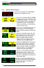
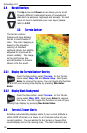
2.5 Satellite Status Indicators
Directly below the navigation box
are the satellite status indicators.
There are four indicators, upper-
left is the status of the
ORBCOMM satellite connection,
lower-left is the GPS lock status,
upper right is the WX status
which lets you know what
weather product is being displayed, and lower right is the Msg
status. The indicators will also display an arrow up or down to
show that the system is transmitting or receiving data from the
satellite.
Below these indicators is a small text box that outputs status
information that is written to status log. The text is small because
it is not necessary to read this information during flight.