


EchoMap v3.0
44
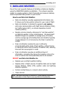
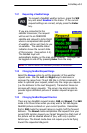
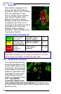
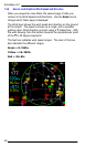
7.3.1 Storm Cells
Storm activity is displayed on the
moving map with cells measuring
from 2km to 12km in size. The detail
levels vary depending on many
factors, including size of requested
area, amount of weather, and
distance from center of picture.
Although a higher level of detail can
be displayed, due to the 5 to 10
minute age of the weather and storm
movement it does not provide
additional useful navigational
information. Cells are displayed with
three levels of intensity.
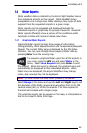
The three levels of intensity are:
G
G
r
r
e
e
e
e
n
n
Light to moderate
rain or snow
0 to 0.05” rain/hr or
0 to 0.5” snow/hr
5 – 29
dbz
Y
Y
e
e
l
l
l
l
o
o
w
w
Moderate to heavy
rain or heavy snow,
possible lightning
0.06 to 1.5” rain/hr or
0.5 to +1” snow/hr
30 – 54
dbz
R
R
e
e
d
d
Extreme
rain/sleet/hail,
lightning
+2.5” rain/hr or
sleet/hail
55 + dbz
WARNING - You should always assume that weather intensity
levels have increased since the image was received. You should
not fly close to any activity, including the green cells!
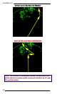
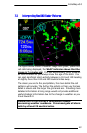
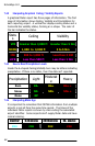
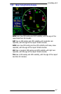
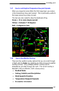
7.3.2 NexRAD Picture Boundaries
Two concentric dashed circles
denote the boundaries of the
current weather picture on the
moving map. The inner green
circle indicates the area where
weather is represented in the
most detail. The outer yellow
circle indicates where the
weather is represented in less
detail. Any weather
completely outside of the
outer yellow circle will not be displayed. Cells display when
any part contacts the outer yellow circle, so large cells can extend
beyond the circle.