


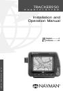


6 TRACKER950 CHARTPLOTTER Installation and Operation Manual
NAVMAN
1 Introduction
Congratulations on choosing the NAVMAN
TRACKER950 chartplotter. For maximum benefit,
please read this manual carefully before installing
and using the unit. Special terms are explained in
Appendix C.
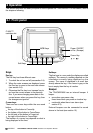
The TRACKER950
The TRACKER950 chartplotter is a compact,
ruggedly built, highly integrated navigation
instrument. It has been designed to be easy to
use. Complex navigation functions can be
performed with a few key presses, taking the hard
work out of navigation. It has an easy to read,
colour display.
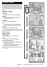
The TRACKER950 has a built-in chart of the world,
suitable for route planning and general interest.
You can see extra details by plugging in a C-MAP™
electronic chart cartridge for the region where you
are navigating.
The TRACKER950 receives information from the
GPS system and displays the boat’s position and
speed.
To navigate with the TRACKER950, you can go
directly to any point on the chart or you can create
routes for the boat to follow. When the boat is
navigating to one of these points, the unit displays
course information for the helmsman to follow.
The TRACKER950 can send data to an autopilot
or radar and can repeat depth information from a
depth sounder. With an optional fuel kit, the
TRACKER950 becomes a sophisticated yet easy
to use fuel computer. An optional PC interface kit
allows you to download waypoints and routes from
a Windows based PC.
Chart accuracy
C-MAP™ electronic charts are derived from
geographical data (including official government
charts) which are not verified or approved by
Hydrographic Authorities. C-MAP™ electronic
charts are designed only to simplify navigation
calculations. They must be used with official charts
and prudent navigation habits, rather than as a
primary source of navigation information.
There is no direct relationship between the colour
of water areas and their depth. The navigator shall
always check depth and use official paper charts.
The GPS system
The US government is solely responsible for the
operation, accuracy and maintenance of the GPS
satellites. They are subject to changes that will
affect the performance and accuracy of all GPS
receivers.
The civilian GPS signals may very occasionally
be turned off. This unit will not work if its power
fails. You must guard against these events by
always having another way of navigating.
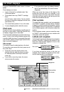
Cleaning and maintenance
Clean the TRACKER950 case with a damp cloth
or mild detergent. Avoid abrasive cleaners and
petrol or other solvents.
Keep the protective cover over the slot for the
C-MAP™ cartridge at all times. If the slot gets
dirty, clean it by blowing the dirt out. If it gets wet,
clean it with clean fresh water and dry it with warm,
dry air.
Clip the dust cover over the display when you are
not using the unit or if you remove the unit from
the boat.
1-1 Care
C-MAP™ cartridges
Handle the cartridges carefully. Keep them in their
protective cases when not plugged into the
TRACKER950. If they get dirty or wet, clean them
with a damp cloth or mild detergent.