


16 TRACKER950 CHARTPLOTTER Installation and Operation Manual
NAVMAN
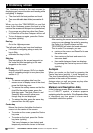
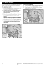
3-3 Mapshift screen and datums
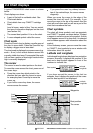
Satellite derived positions are based on a
worldwide reference (datum) known as WGS84.
Some paper charts are based on datums other
than WGS84. This results in an offset between a
latitude and longitude plotted on the paper chart
and the same latitude and longitude plotted on the
TRACKER950. To match the TRACKER950 with
your local charts you must enter the datum for your
local area (see Appendix A for a list of available
datums). Once your local datum has been entered
all latitudes and longitudes, including waypoints,
will match the paper charts (see section 9-2).
If you prefer to retain the WGS84 datum (no local
datum) but find that the boat position is offset you
can correct this offset with the mapshift function.
Warning: Mapshift is for eliminating minor
offsets. It must not be used to correct positions
to match local charts.
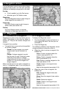
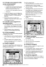
To set mapshift
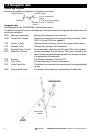
1 Move your boat to a known point on the
chart, for example a marina berth.
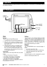
2 Press the Esc key until it displays the Fuel or
Position screen. Press the Sat key to display
the Satellite Status screen.
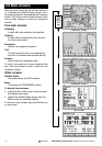
3 Press the Mapshft key to display the
Mapshift screen.
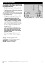
4 The GPS position is shown as a cross in a
circle. Press the cursor keys to move the
cursor to the position on the chart where the
boat actually is.
5 Press the Set key to set the new mapshift.
The boat will now be displayed at its actual
location.
6 The Mapshift offset is displayed in the
navigation data window. Check the setting by
performing the same procedure at other
known locations.
To clear mapshift
1 Press the Esc key until it displays the Fuel or
Position screen. Press the Sat key to display
the Satellite Status screen.
2 Press the Mapshft key to display the
Mapshift screen.
3 Press the Clear key.