


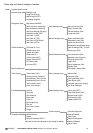
29TRACKER950 CHARTPLOTTER Installation and Operation Manual
NAVMAN
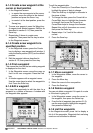
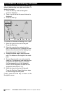
Satellite Status screen
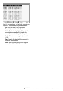
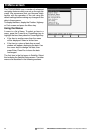
General Setup Backlight (16)
Local time Ofst (0)
NMEA output (OFF)
Language (English)
Navigation Setup Map datum (WGS84)
North reference (Automag) Land Settings menu Natural features (ON)
Map orientation (North Up) Rivers & lakes (ON)
Velocity averaging (20 secs) Cultural features (ON)
Projected course (OFF) Landmarks (ON)
User Data 1 (XTE)
User Data 2 (TTG) Marine Settings menu Water turbulence (ON)
User Data 3 (CDI Scale) Bathometric lines (ON)
User Data 4 (ETA) Depth area limits (000)
Bathometrics & soundings range
CDI/Units/Alarms CDI scale (0.1 nm) Spot soundings (ON) (0-15m)
Distance units (nm) Bottom type (ON)
Speed units (Kts)
Depth units (m) Nav-aids/features menu Ports & services (ON)
Arrival radius (OFF) Attention areas (Contour)
Anchor alarm (OFF) Tracks & routes (ON)
XTE alarm (ON) Lights (ON)
Low fuel (OFF) Bouys & beacons (ON)
Signals (ON)
Map Configuration Cartograph. objects (ON)
Track History Track history (ON) Other Settings menu Names (ON)
Plotting interval (Distance) Compass (ON)
Resolution by dist (0.05 nm) Chart generation (ON)
Resolution by time (10 sec) New objects (ON)
Track memory used Complex object icon (Single)
Clear track memory Info level (Detailed)
Fuel Setup Tank full Chart Settings menu Lat/lon grid (OFF)
Tank size Chart boundaries (ON)
Set remaining Waypoint icons (ON)
Clear used Track display (ON)
Units (L) Plotter mode (OFF)
Num engines (0)
Fuel cal
Flow filter (10 sec)
Range
Communication Send All Waypoints
Simulation Mode Mode (Normal) Send All Routes
Speed Send Track
Activate simulation (OFF) Delete All Waypoints
(the other menu items depend on the setting for Mode) Delete All Routes
Delete Track
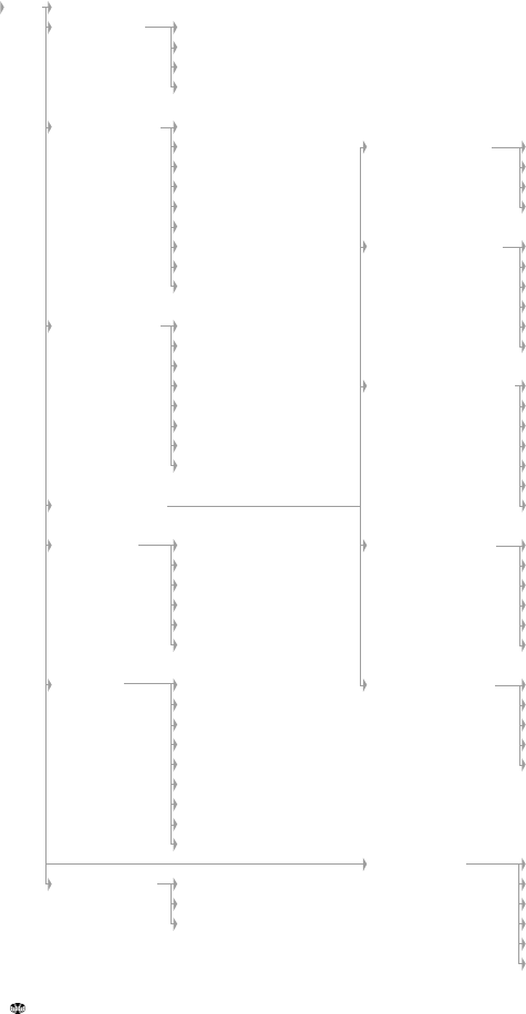
Menu map, with default settings in brackets
Menu