


Magellan Meridian FAQ – Version 2.0
Page 8 of 30
10) Memory Usage – How much memory is left?
When using your unit, eventually you will run into memory limits. You can check the percentage of free space
remaining for Maps (SD card space), Routes, Waypoints and Track History. To do this, simply press Menu, then
select About.
11) Detailed Maps -- How do I do it?
Detailed maps can provide a lot more detail than the built-in base map. The base map is shown when zoomed out,
but the data in the detailed map begins to display when the unit is zoomed it. The detailed map will have every road
for an area. The Topo map will also include rough contour lines with elevations (topographical map). The Streets
& Destination map will feature POI (Points Of Interest) data which includes restaurants, hotels, golf courses,
marinas, tourist attractions, art galleries, museums, gardens, and the like.
The first thing that you need is mapping software (described later). You will also need a place to put the maps - the
SD card (see above). A SD card writer would also be well worth the nominal investment. After you buy the
software, go to the Magellan web site (www.magellangps.com) and check for updates or special instructions for the
mapping software.
Now you’re in business. Using the MapSend software, create up to four different rectangular regions for upload to
the GPS. When the regions are uploaded, they will be combined into one file on your SD card. The details will
differ depending upon whether you are using a SD writer or the serial port, and on which map software that you
have.
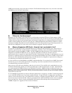
12) Detailed Maps -- What if I don’t have a base map?
Sometimes people who own Meridians travel to different continents. It may happen that a person has a North
American Meridian, but uses the MapSend European Streets program during a vacation. Conversely, a person with
a European base map may travel to America and use the American version of Streets. Unfortunately, problems have
been reported in these cases. When the map is zoomed out, you don’t see any detail because the base map doesn’t
contain it. In order to see any roads at all, the map must be zoomed in, which prevents you from getting a “bird’s
eye” view of the area. Furthermore, the names of the cities and towns are not ever shown, because this data is kept
only in the base map.
Unfortunately, the only thing you can do to remedy this situation is to upload a different base map to the unit or use
the WorldWide base map product.
13) Detailed Maps -- What software is available?
This section details software listed on the Magellan web site. These detailed mapping packages can be used with any
basemap but please note the comments in 11) above.
DataSend – The DataSend line of products is intended for the Magellan 315 line. They will not work with a
Meridian. Do not even try. It is available in an American and European version.
MapSend Streets – Street maps and limited POI. This is available for the US, and Australia. The Australian
version charges a fee for each state purchased. When commenting on the European version, "Skramblr" reported,
“Maybe Magellan should rename the program to: Mapsend Western Europe, except Ireland, Norway, and
Finland.”
MapSend Streets & Destinations – This uses a slightly updated road database that fixes some errors, and is
available in US and Canadian versions. It also offers a fairly comprehensive database of POI data, which includes
all of the sorts of things that a tourist might be interested in. This version of software is commonly referred to as
MapSend S&D.
MapSend Topo – For the US. Same as MapSend S&D, but adds topographical data. Note that this is rough data,
and will not show every little ravine. Apparently, the topographic data has approximately 90M horizontal
resolution. If you are planning to do some serious hiking or mountain climbing, don't forget the paper map!
MapSend DirectRoute – As of this writing, this product is just becoming available. It provides auto-routing with
turn-by-turn guidance, will use more accurate NavTech map data, and cover both Canada and the USA. Another