


Magellan Meridian FAQ – Version 2.0
Page 6 of 30
typically come from the Magellan Support website, Firmware update CDs, or the occasional tech support
email response.
Standard Base Map – This memory size is 2MB in the yellow/green models and 16MB in all other
models. It can hold a standard base map only (no detailed maps). This map comes in North American,
European, and Australian version with both standard and marine flavors available. A majority of the road
detail is deleted and it has a limited number of points-of-interest (POI). Cities removed from this database
do no appear in the city list, even if a detailed map is uploaded.
SD Card Memory
Detailed Maps – These maps are created by programs like Magellan MapSend Streets, Streets &
Destinations, Topo, DiscoverAus Streets and Tracks software or DirectRoute, and contain street-level detail
and points -of-interest (POI) data. For more information see Section “Detailed Maps -- What software is
available?”
BlueNav Map – This contains detailed marine information and charts, and comes from the BlueNav
product.
WorldWide Basemap – This is a replacement for the standard base map. It is created by the WorldWide
Basemap product, and cannot be loaded into the internal FLASH memory.
Note on standard Basemap files – can I put them on SD card? In general, the Basemap files cannot be
used like detailed maps, by having multiple files placed on the SD card and activated as needed. They can
only function from the internal memory.
7) Base Maps -- What's the deal?
Each Meridian unit ships with a base map. This base map includes the following: political boundaries of all
countries in the world, all major cities in the world, and most major lakes of the world. The 16MB US version of
the base map (not for the Meridian Green) contains the following: boundaries of all US states, almost all US cities
and towns, the entire US interstate system, most major state highways, all medium-sized lakes in the US, US
National parks. The European base map adds city and major street data for most Eastern European countries, with
very little detail for most Western European countries. An Australian base map is also available with good city and
major street detail. There are also marine versions of all of the base maps. These add details about marine
navigational aids such as buoys and lighthouses. This marine data does NOT include data for inland water such as
lakes and rivers. The Meridian green/yellow comes with a 2MB base map which lacks most of the detail of its
bigger 16M B brother. 2MB maps are not available in a marine version.
Even if a detailed map is loaded, it is the base map that that is seen when the map screen is zoomed out – the base
map gives you the “bird’s eye” view. If you have a detailed map loaded, but have poor base map coverage, then it is
possible to see the streets of a city and not be able to see the name of the city itself.
The cost of your Meridian includes one base map. Although the Meridian Marine is exactly the same GPS as the
Gold, it costs more because Magellan had to license the marine POI database. It is possible to upgrade a Gold or
Platinum with the marine base map.
Although you cannot swap between multiple base maps using an SD card, you can have a single basemap saved on
the SD card as basemap.img. Then by using the hidden menu command 86, the file will be uploaded into the internal
memory (replacing the current basemap). Note that the current basemap will not be stored elsewhere and you cannot
go back to that original basemap (unless you repeat this update process with the original basemap file). This
procedure can be handy when traveling to another continent.
Magellan has a product out called the Mapsend WorldWide Basemap. The software features a base map of the
entire world. Individual regions can be selected and download to an SD card. While loaded, it replaces the internal
base map. Its detail is slightly less than the 16MB maps, and far better than the 2MB maps. Once installed, this
product is tied to a specific Meridian based on the serial number. Maps created by the program will only function
when used on a GPS with a matching serial number. This effectively prevents sharing of the map files.
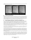
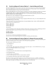
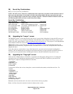
Below is a picture showing the level of USA detail between the Gold basemap, Worldwide Basemap, & Green
Basemap. One can see that the Green’s 2MB basemap only shows a highway in the upper right corner. The Gold’s