


55
tems, you must be in the respective country. This unit will pick the match-
ing datum for you when you select the grid. See the Datums section for
more information.
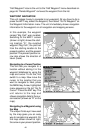
The military grid reference system (MGRS) uses two grid lettering
schemes, which are referred to as standard and alternate MGRS on this
unit. Your position and datum in use determines which one to use. If you
use standard, and your position is off significantly, then try the alternate.
Note: When the position format is changed, it affects the way all positions
are shown on all screens. This includes waypoints.
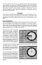
Some screens have two position displays, standard, which is also shown
on all other position displays, and alternate. The alternate position can be
programmed to show your present position in a different format than the
upper position. For example, you can show latitude/longitude and UTM’s
at the same time.
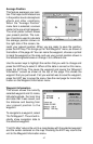
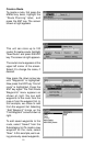
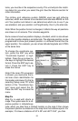
To change the coordinate sys-
tem, press the ENT key while
“Coordinate System” is high-
lighted. Press the up or down ar-
row keys to highlight the desired
format. Press the ENT key to se-
lect it. Press the EXIT key to
erase the menus.
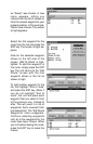
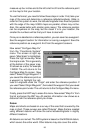
Note: If the Loran TD conversion
is chosen, you must enter the lo-
cal loran chain identification for
the master and slaves. Do this by
selecting “Setup Loran TD” at the
bottom of the “Coordinate Sys-
tem” menu and select the ID.
Press the EXIT key to erase this
menu.
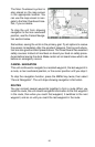
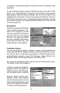
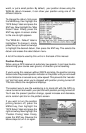
Map Fix
Map Fix is used with charts or
maps. This system asks for a ref-
erence position in latitude/longi-
tude, which you take from a marked location on the map. It then shows
the present position as distance on the map from that reference point. For
example, if it shows a distance of UP 4.00” and LEFT 0.50”, you then