


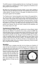

37
To turn the cursor on, simply
press the arrow key in the direc-
tion you want the cursor to move.
This lets you view areas on the
plotter that are away from your
present position. The zoom-in
and zoom-out keys work from the
cursor’s position when it’s active
- not the present position. You can
zoom in on any detail, anywhere.
The cursor can also place icons
and waypoints.
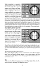
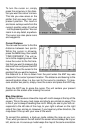
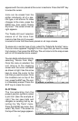
Cursor Distance
You can use the cursor to find the
distance between two points.
While the cursor is showing,
press the MENU key, then select
“FIND DISTANCE”. The unit re-
turns to the mapping screen. Now
move the cursor to the first loca-
tion that you want to measure the
distance from and press the ENT
key. Next, move the cursor to the
position that you want to measure
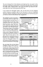
the distance to. A line is drawn from the point when the ENT key was
pressed to the cursor’s present location. The distance and bearing to the
second location show in a box next to the cursor’s crosshairs. To mea-
sure another two points, simply move the cursor and press the ENT key.
Press the EXIT key to erase the cursor. The unit centers your present
position on the screen after erasing the cursor.
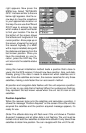
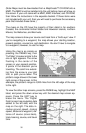
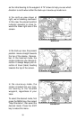
Map Orientation
By default, this receiver shows the map with north always at the top of the
screen. This is the way most maps and charts are printed on paper. This
is fine if you’re always travelling due north. What you see to your left cor-
responds to the left side of the map, to your right is shown on the right
side of the map, and so on. However, if you travel any other direction, the
map doesn’t line up with your view of the world.
To correct this problem, a track-up mode rotates the map as you turn.
Thus, what you see on the left side of the screen should always be to your
left, and so on. A course-up mode keeps the map at the same orientation