


35
(Note: Maps must be downloaded from a MapCreate™ CD-ROM onto a
MMC. The MMC must be installed into the unit before maps will show on
the screen. If your unit came with a MMC, MMC Interface, and CD-ROM,
then follow the instructions in the separate booklet. If these items were
not included with your unit, then you will need to purchase the accessory
pack that includes these items.)
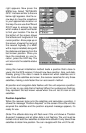
The maps on the CD have the majority of their detail in far southern
Canada, the continental United States and Hawaiian islands, northern
Mexico, the Bahamas, and Bermuda.
The map screens show your course and track from a “bird’s-eye” view. If
you’re navigating to a waypoint, the map shows your starting location,
present position, course line, and destination. You don’t have to navigate
to a waypoint, however, to use the map.
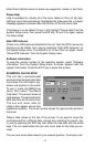
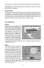
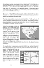
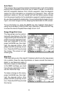
Using the map is as simple as
pressing the PAGES key, then
“Full Map”. A screen similar to the
one at right appears. The arrow
flashing in the center of the
screen is your present position.
It points in the direction you’re
travelling. The solid line extend-
ing from the arrow is your plot
trail, or path you’ve taken. The
plotter’s range shows in the lower
right corner of the screen. In this
example, the plotter’s range is 4,000 miles from the left edge of the map
to the right.
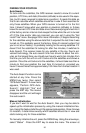
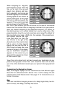
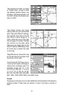
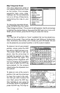
To view the other map screens, press the PAGES key, highlight the MAP
label, and press the down arrow key until the desired map screen ap-
pears. Press the EXIT key to
erase the menu. The “Digital
Data” screen has navigation data
added to the left side, with the
map on the right. The data in-
cludes ground speed, closing
speed, distance to waypoint, dis-
tance off course (cross-track),
track, bearing, course, and travel
time.