


40
Map Categories Drawn
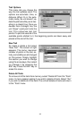
This menu determines which of
the mapping features are shown
on the screen. This includes,
waypoints, trails, icons, cities,
highways, etc. You can selectively
turn on or off any of these items,
customizing the map to your
needs.
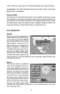
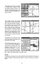
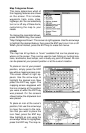
To change the map detail shown,
press the MENU key, then select
“Map Catagories Drawn”. The screen at right appears. Use the arrow keys
to highlight the desired feature, then press the ENT key to turn it on or off.
When you’re finished, press the EXIT key to erase the menus.
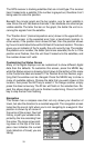
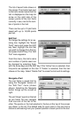
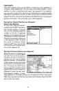
ICONS
The map has 42 symbols or “icons” available that can be placed any-
where on the screen. They can be used to mark fishing or hunting loca-
tions, landmarks, boat ramps, and virtually any point of interest. An icon
can be placed at your present position or at the cursor’s location.
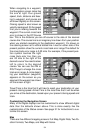
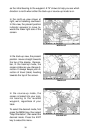
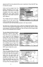
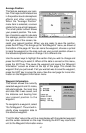
To place an icon at your present
position, simply press the ENT
key while a mapping screen is on.
The screen shown at right ap-
pears. Use the arrow keys to
highlight the desired icon. Now
press the ENT key again. The
mapping screen reappears with
the icon showing at the position
you were at when the ENT key
was pressed. On the screens
shown below, the shipwreck icon
was placed.
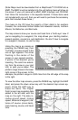
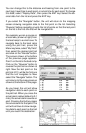
To place an icon at the cursor’s
position, first use the arrow keys
to move the cursor to the loca-
tion that you wish to place the
icon. Next, press the ENT key.
Now highlight an icon using the
arrow keys. While it’s highlighted,
press the ENT key. The map re-