


29
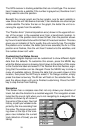
The system requires three satellites in order to determine a position. This
is called a 2D fix. It takes four satellites to determine both position and
elevation (your height above sea level - also called altitude.) This is called
a 3D fix.
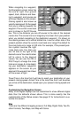
Remember, the unit must have a clear view of the satellites in order to
receive their signals. Unlike radio or television, GPS works at very high
frequencies. The signals can be blocked easily by trees, covered docks,
even your body.
Never use this GPS receiver while operating a vehicle!
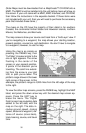
Like most GPS receivers, this unit doesn’t have a compass or any other
navigation aid built inside. It relies solely on the signals from the satellites
to calculate a position. Speed, direction of travel, and distance are all
calculated from position information. Therefore, in order for it to determine
direction of travel, you must be moving and the faster, the better. This is
not to say that it won’t work at trolling speeds - it will. There will simply be
more “wandering” of the data shown on the display.
If you want better performance, many manufacturers (including Lowrance)
sell a DGPS receiver that attaches to your GPS receiver. The DGPS sys-
tem transmits correction signals that increase the accuracy to about 10
meters. The DGPS receiver takes signals from these land-based trans-
mitters and gives them to the GPS receiver which then uses them to
show a more accurate position. (You can use the signals from all of the
Coast Guard DGPS stations for free, by the way.) The downside to this is
it requires another piece of electronic gear (the DGPS receiver). And you
have to be close enough to a station to receive the DGPS signals.
Generally, you find that using your GPS receiver without DGPS is both
easy and amazingly accurate. It’s easily the most accurate method of
electronic navigation available to the general public today. Remember,
however, that this receiver is only a tool. Always have another method of
navigation available, such as a chart and a compass.
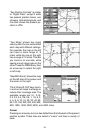
Also remember that this unit will always show navigation information in
the shortest line from your present position to a waypoint, regardless of
terrain! It only calculates position, it can’t know what’s between you and
your camp, for example. It’s up to you to safely navigate around obstacles,
no matter how you’re using this product.